IMAGES TAKEN NEAR TO
Lovatt Close, CARTERTON, OX18 1FA
Introduction
This page details the photographs taken nearby to Lovatt Close, OX18 1FA by members of the Geograph project.
The Geograph project started in 2005 with the aim of publishing, organising and preserving representative images for every square kilometre of Great Britain, Ireland and the Isle of Man.

There are currently over 7.5m images from over14,400 individuals and you can help contribute to the project by visiting https://www.geograph.org.uk
Image Map (Loading...)


Getting Data...Please wait
Leaflet Map data © OpenStreetMap
Images are licensed for reuse under creativecommons.org/licenses/by-sa/2.0
Notes
- Clicking on the map will re-center to the selected point.
- The higher the marker number, the further away the image location is from the centre of the postcode.
Image Listing (24 Images Found)
Images are licensed for reuse under creativecommons.org/licenses/by-sa/2.0
Image
Details
Distance
2
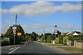
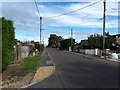
Swinbrook Road, Carterton
With signs showing weight limit, and that Kilkenny Lane is closed. The yellow sign states access to football club and allotments only.
Image: © andrew auger
Taken: 26 Sep 2009
0.09 miles
3
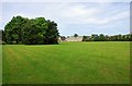
Field adjacent to Squash Club, Carterton, Oxon
This field is connected by footpaths to nearby housing estates and the grass is regularly cut. It is used by walkers, including dog walkers. There are some seats and dog waste bins. The building with a flat roof, in the far distance, is home to Carterton Squash and Squash 57 (Racketball) Club. Road access to this is by Baldwin Mews, off Swinbrook Road.
Image: © P L Chadwick
Taken: 28 May 2017
0.12 miles
4
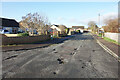
Potholes, Burswin Road
A lot of smart new roads are going in on all the building sites round here, but meanwhile older stuff is left to fall apart.
Image: © Des Blenkinsopp
Taken: 15 Dec 2020
0.13 miles
5
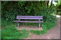
Bench seat, Carterton ,Oxon
Located near a footpath to Flax Crescent and Harvest Bank.
Image
Image: © P L Chadwick
Taken: 28 May 2017
0.14 miles
6
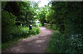
Footpath to Flax Crescent & Harvest Bank, Shilton Park Estate, Carterton, Oxon
This footpath leads to two roads on the Shilton Park Estate. The wooden fencing is where the footpath crosses a small stream or drainage ditch by a footbridge. Just before this, on the left, is a dog waste bin.
Image: © P L Chadwick
Taken: 28 May 2017
0.15 miles
7

Air Ambulance flying over field adjacent to Flax Crescent, Carterton, Oxon
The Thames Valley Air Ambulance helicopter had just taken off from the field. See:- Image
Image: © P L Chadwick
Taken: 10 Feb 2020
0.15 miles
8

Air Ambulance taking off from field adjacent to Flax Crescent, Carterton, Oxon
The helicopter is operated by Thames Valley Air Ambulance, a registered charity. It covers Berkshire, Buckinghamshire & Oxfordshire. I don't know what it was doing on this particular occasion, possibly it was a training exercise.
Image
Image: © P L Chadwick
Taken: 10 Feb 2020
0.15 miles
9
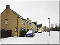
Flax Crescent in the snow, Shilton Park Estate, Carterton, Oxon
A snowy scene in early March.
Image: © L S Wilson
Taken: 3 Mar 2018
0.17 miles
10
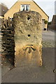
Benchmark on milestone outside #20a Shilton Road
Ordnance Survey cut mark benchmark described on the Bench Mark Database at http://www.bench-marks.org.uk/bm82297
Image: © Roger Templeman
Taken: 20 Feb 2017
0.17 miles