IMAGES TAKEN NEAR TO
Brizewood, CARTERTON, OX18 1DF
Introduction
This page details the photographs taken nearby to Brizewood, OX18 1DF by members of the Geograph project.
The Geograph project started in 2005 with the aim of publishing, organising and preserving representative images for every square kilometre of Great Britain, Ireland and the Isle of Man.

There are currently over 7.5m images from over14,400 individuals and you can help contribute to the project by visiting https://www.geograph.org.uk
Image Map (Loading...)


Getting Data...Please wait
Leaflet Map data © OpenStreetMap
Images are licensed for reuse under creativecommons.org/licenses/by-sa/2.0
Notes
- Clicking on the map will re-center to the selected point.
- The higher the marker number, the further away the image location is from the centre of the postcode.
Image Listing (16 Images Found)
Images are licensed for reuse under creativecommons.org/licenses/by-sa/2.0
Image
Details
Distance
1
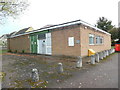
Carterton Telephone Exchange, Oxon
Situated on the B4020 Shilton Road, this redbrick building has the code SMCAR. It provides telephone and broadband services to 6,550 residential and 214 non-residential premises in Carterton plus Alvescot, Black Bourton, Brize Norton and Shilton nearby. Two white BT warning notices can be seen at the front of this TE, whilst a yellow grit salt bin is at the side. The numbering range of this TE is (01993) 84xxxx, the (01993) referring to the Witney group of ten TEs, and its postcode is OX18 1EN.
Image: © David Hillas
Taken: 26 Oct 2018
0.11 miles
2
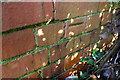
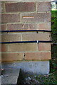
Benchmark on wall of Upavon Way at Burford Road junction
Ordnance Survey cut mark benchmark described on the Bench Mark Database at http://www.bench-marks.org.uk/bm79883
Image: © Roger Templeman
Taken: 20 Feb 2017
0.18 miles
3
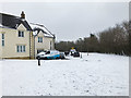
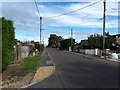
Stocks Lane in snow, Shilton Park Estate, Carterton, Oxon
A snowy scene in early March.
Image: © L S Wilson
Taken: 3 Mar 2018
0.19 miles
4
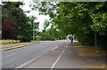
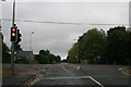
Junction of Burford Road, Upavon Way and Shilton Road, Carterton, Oxon
The junction of the three roads is controlled by traffic lights. In the foreground is Burford Road. The road going from left to right is Upavon Way (B4477). Straight ahead, in the distance, is Shilton Road (B4020). This goes to Burford.
Image: © P L Chadwick
Taken: 4 Jun 2020
0.19 miles
5
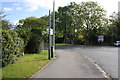
Junction of Upavon Way and Burford Road
There is an OS benchmark Image on the wall behind the bush on the far side of the gap between the two bushes at the left hand side of the image
Image: © Roger Templeman
Taken: 18 Oct 2016
0.19 miles
7
Traffic lights in Carterton
Upavon way meets the Burford Road (to the right) and Shilton Road (to the left)
Image: © andrew auger
Taken: 3 Oct 2009
0.20 miles
8
Benchmark on #150 Britannia Close
Ordnance Survey cut mark benchmark described on the Bench Mark Database at http://www.bench-marks.org.uk/bm80118
Image: © Roger Templeman
Taken: 18 Oct 2016
0.20 miles
9
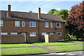
Houses on Britannia Close
There is an OS benchmark Image on the front face of the right hand house at its far corner, right of a black downpipe
Image: © Roger Templeman
Taken: 18 Oct 2016
0.20 miles
10
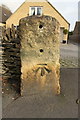
Benchmark on milestone outside #20a Shilton Road
Ordnance Survey cut mark benchmark described on the Bench Mark Database at http://www.bench-marks.org.uk/bm82297
Image: © Roger Templeman
Taken: 20 Feb 2017
0.21 miles