IMAGES TAKEN NEAR TO
Elmhurst Way, CARTERTON, OX18 1BW
Introduction
This page details the photographs taken nearby to Elmhurst Way, OX18 1BW by members of the Geograph project.
The Geograph project started in 2005 with the aim of publishing, organising and preserving representative images for every square kilometre of Great Britain, Ireland and the Isle of Man.

There are currently over 7.5m images from over14,400 individuals and you can help contribute to the project by visiting https://www.geograph.org.uk
Image Map (Loading...)


Getting Data...Please wait
Leaflet Map data © OpenStreetMap
Images are licensed for reuse under creativecommons.org/licenses/by-sa/2.0
Notes
- Clicking on the map will re-center to the selected point.
- The higher the marker number, the further away the image location is from the centre of the postcode.
Image Listing (47 Images Found)
Images are licensed for reuse under creativecommons.org/licenses/by-sa/2.0
Image
Details
Distance
1
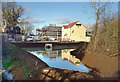
New Holding Pond, Elmhurst Way
Recently constructed to contain storm run off from a new development site and release it slowly into the small watercourse just visible bottom left.
Heavy rain over the last few days shows it seems to be working ok.
Image: © Des Blenkinsopp
Taken: 15 Dec 2020
0.09 miles
2
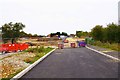
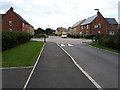
The end of Elmhurst Way, Shilton Park, Carterton, Oxon
Although this photograph was taken several months ago, the road is still blocked here at present (August 2016). Beyond there has been considerable progress with the building of a new housing estate known as Swinbrook Park. This is at the higher end of the market with three and four bedroom houses currently under construction. Presumably at some stage this road between the Swinbrook Park estate and the adjacent Shilton Park estate will be opened.
Image: © P L Chadwick
Taken: 17 Oct 2015
0.09 miles
3
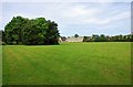
Field adjacent to Squash Club, Carterton, Oxon
This field is connected by footpaths to nearby housing estates and the grass is regularly cut. It is used by walkers, including dog walkers. There are some seats and dog waste bins. The building with a flat roof, in the far distance, is home to Carterton Squash and Squash 57 (Racketball) Club. Road access to this is by Baldwin Mews, off Swinbrook Road.
Image: © P L Chadwick
Taken: 28 May 2017
0.09 miles
4
Bollards in Swinbrook Road
The top end of Swinbrook Road has been blocked off for some reason.
Image: © Des Blenkinsopp
Taken: 15 Dec 2020
0.10 miles
5
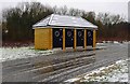
Public toilets, Kilkenny Lane Country Park, Carterton, Oxon
Opened fairly recently, this block of four coin-operated public toilets are by the car park, off Elmhurst Way.
Image: © P L Chadwick
Taken: 21 Jan 2018
0.10 miles
7
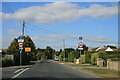
Swinbrook Road, Carterton
With signs showing weight limit, and that Kilkenny Lane is closed. The yellow sign states access to football club and allotments only.
Image: © andrew auger
Taken: 26 Sep 2009
0.11 miles
8
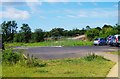
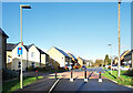
Kilkenny Lane Country Park car park, off Elmhurst Way, Carterton, Oxon
This small car park serves the Country Park which for many people living in Carterton is within walking distance. Beyond the car park, preparations were under way for a further residential expansion to the town.
Image: © P L Chadwick
Taken: 27 Jun 2015
0.11 miles
9

Air Ambulance taking off from field adjacent to Flax Crescent, Carterton, Oxon
The helicopter is operated by Thames Valley Air Ambulance, a registered charity. It covers Berkshire, Buckinghamshire & Oxfordshire. I don't know what it was doing on this particular occasion, possibly it was a training exercise.
Image
Image: © P L Chadwick
Taken: 10 Feb 2020
0.13 miles
10

Air Ambulance flying over field adjacent to Flax Crescent, Carterton, Oxon
The Thames Valley Air Ambulance helicopter had just taken off from the field. See:- Image
Image: © P L Chadwick
Taken: 10 Feb 2020
0.13 miles