IMAGES TAKEN NEAR TO
The Square, BANBURY, OX17 3RE
Introduction
This page details the photographs taken nearby to The Square, OX17 3RE by members of the Geograph project.
The Geograph project started in 2005 with the aim of publishing, organising and preserving representative images for every square kilometre of Great Britain, Ireland and the Isle of Man.

There are currently over 7.5m images from over14,400 individuals and you can help contribute to the project by visiting https://www.geograph.org.uk
Image Map
Images are licensed for reuse under creativecommons.org/licenses/by-sa/2.0
Notes
- Clicking on the map will re-center to the selected point.
- The higher the marker number, the further away the image location is from the centre of the postcode.
Image Listing (154 Images Found)
Images are licensed for reuse under creativecommons.org/licenses/by-sa/2.0
Image
Details
Distance
1
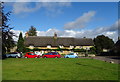
Thatched cottages on The Square, Kings Sutton
Image: © JThomas
Taken: 28 Sep 2019
0.00 miles
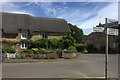
4
Thatched house on Whittall Street, Kings Sutton
Image: © JThomas
Taken: 28 Sep 2019
0.01 miles
5
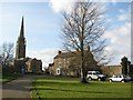
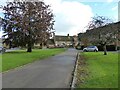
The Village Green, King's Sutton
A beautiful picture of the entire village green at King's Sutton. Here we can see the many traditional character properties around the green, plus the very distinctive church of St Peter & St Paul, with its impressive steeple which is seen for miles around.
Image: © Kurt C
Taken: 1 Mar 2009
0.02 miles
6
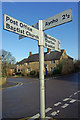
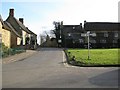
Crossroads in Kings Sutton
The signpost points to various destinations within and beyond this south west Northamptonshire village. The name King's Sutton derives from King William I who held the manor in 1086.
Image: © Stephen McKay
Taken: 17 Jan 2010
0.02 miles
7
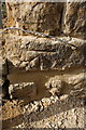
Benchmark on #2 Whittall Street
Ordnance Survey cut mark benchmark described on the Bench Mark Database at http://www.bench-marks.org.uk/bm48187
Image: © Roger Templeman
Taken: 18 Apr 2013
0.02 miles
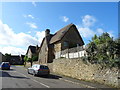
8
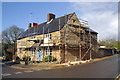
House at junction of Whittall Street and Astrop Road
There is an OS benchmark Image on the corner of the house near the traffic cone
Image: © Roger Templeman
Taken: 18 Apr 2013
0.02 miles
9
King's Sutton Green (Astrop Road Crossroads)
This image, facing South towards Mill Lane and the White Horse Pub (left background), is of Astrop Road and it's crossroads near the village green. Here in King's Sutton, there are no particularly busy lanes or roads, but all roads and lanes seem to be very well marked and signposted. The village green to the right here, has a wonderful view of the church with its especially high steeple, which is seen for miles around.
Image: © Kurt C
Taken: 1 Mar 2009
0.02 miles
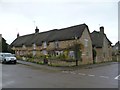
10
The Square, Kings Sutton
The White Horse Inn is in the background.
Image: © Adrian Taylor
Taken: 25 Oct 2020
0.02 miles