IMAGES TAKEN NEAR TO
Walton Avenue, BANBURY, OX17 3LA
Introduction
This page details the photographs taken nearby to Walton Avenue, OX17 3LA by members of the Geograph project.
The Geograph project started in 2005 with the aim of publishing, organising and preserving representative images for every square kilometre of Great Britain, Ireland and the Isle of Man.

There are currently over 7.5m images from over14,400 individuals and you can help contribute to the project by visiting https://www.geograph.org.uk
Image Map (Loading...)


Getting Data...Please wait
Leaflet Map data © OpenStreetMap
Images are licensed for reuse under creativecommons.org/licenses/by-sa/2.0
Notes
- Clicking on the map will re-center to the selected point.
- The higher the marker number, the further away the image location is from the centre of the postcode.
Image Listing (11 Images Found)
Images are licensed for reuse under creativecommons.org/licenses/by-sa/2.0
Image
Details
Distance
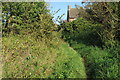
1
Rochester Way, Twyford
Most of Twyford dates from the second half of the 20th century.
Image: © Des Blenkinsopp
Taken: 22 Sep 2020
0.08 miles
2
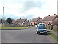
Twyford
Houses in Twyford between Aynho Road, Banbury Road and Twyford Road.
Image: © Dennis Turner
Taken: 9 Apr 2006
0.12 miles
3
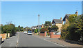
Walton Avenue, Twyford
Most of Twyford dates from the second half of the 20th century.
Image: © Des Blenkinsopp
Taken: 22 Sep 2020
0.15 miles
4
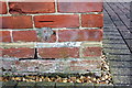
Benchmark on former police house, Banbury Road
Ordnance Survey cut mark benchmark described on the Bench Mark Database at http://www.bench-marks.org.uk/bm48077
Image: © Roger Templeman
Taken: 12 Apr 2013
0.19 miles
5
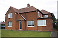
House at junction of Banbury Road and Kemps Road
There is an OS benchmark Image on the side of the house at the far corner
Image: © Roger Templeman
Taken: 12 Apr 2013
0.19 miles
6
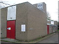
Telephone Exchange, Adderbury
This TE, which is of a standard design, is situated on the B4100 Aynho Road, and replaced a smaller building in the same village during the early 1970s. It has the code SMAD and supplies telephone and broadband services to 2,256 residential and 99 non-residential premises in Adderbury, plus Charlton, Kings Sutton and Twyford nearby. The BT warning notices can be seen on the front of the building, and the red painted doors have improved its appearance. This TE has (01295) 810xxx, 811xxx numbers, the (01295) referring to the Banbury group of thirteen TEs, and its postcode is OX17 3NL.
Image: © David Hillas
Taken: 27 Apr 2013
0.20 miles
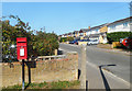
7
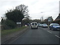
Adderbury (Twyford) village boundary sign
Adderbury is behind us, Twyford in front.
Image: © Colin Pyle
Taken: 27 Feb 2012
0.20 miles
8
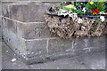
Benchmark on The Pickled Ploughman PH
Ordnance Survey cut mark benchmark described on the Bench Mark Database at http://www.bench-marks.org.uk/bm48160
Image: © Roger Templeman
Taken: 18 Apr 2013
0.20 miles
9
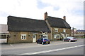
The Pickled Ploughman public house, Aynho Road
There is an OS benchmark Image on the stone base of the bay window below its flower box
Image: © Roger Templeman
Taken: 18 Apr 2013
0.20 miles