IMAGES TAKEN NEAR TO
Margaret Road, BANBURY, OX17 3JE
Introduction
This page details the photographs taken nearby to Margaret Road, OX17 3JE by members of the Geograph project.
The Geograph project started in 2005 with the aim of publishing, organising and preserving representative images for every square kilometre of Great Britain, Ireland and the Isle of Man.

There are currently over 7.5m images from over14,400 individuals and you can help contribute to the project by visiting https://www.geograph.org.uk
Image Map
Images are licensed for reuse under creativecommons.org/licenses/by-sa/2.0
Notes
- Clicking on the map will re-center to the selected point.
- The higher the marker number, the further away the image location is from the centre of the postcode.
Image Listing (12 Images Found)
Images are licensed for reuse under creativecommons.org/licenses/by-sa/2.0
Image
Details
Distance
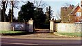
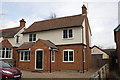
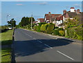
1
Walton Avenue, Twyford
Most of Twyford dates from the second half of the 20th century.
Image: © Des Blenkinsopp
Taken: 22 Sep 2020
0.13 miles
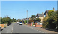
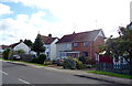
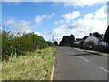
2
A4260 Banbury Road, Twyford
Towards Banbury.
Image: © Robin Webster
Taken: 18 Jul 2021
0.16 miles
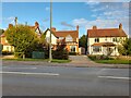
3
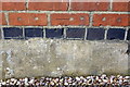
Benchmark on #5 Twyford Gardens
Ordnance Survey cut mark benchmark described on the Bench Mark Database at http://www.bench-marks.org.uk/bm48078
Image: © Roger Templeman
Taken: 12 Apr 2013
0.16 miles
4
#5 Twyford Gardens, Banbury Road
There is an OS benchmark Image on the side of the house near the front corner
Image: © Roger Templeman
Taken: 12 Apr 2013
0.16 miles
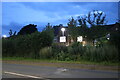
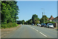
9
Twyford Road, Twyford
Towards Kings Sutton.
Image: © JThomas
Taken: 28 Sep 2019
0.18 miles