IMAGES TAKEN NEAR TO
St. Marys Road, BANBURY, OX17 3EZ
Introduction
This page details the photographs taken nearby to St. Marys Road, OX17 3EZ by members of the Geograph project.
The Geograph project started in 2005 with the aim of publishing, organising and preserving representative images for every square kilometre of Great Britain, Ireland and the Isle of Man.

There are currently over 7.5m images from over14,400 individuals and you can help contribute to the project by visiting https://www.geograph.org.uk
Image Map
Images are licensed for reuse under creativecommons.org/licenses/by-sa/2.0
Notes
- Clicking on the map will re-center to the selected point.
- The higher the marker number, the further away the image location is from the centre of the postcode.
Image Listing (10 Images Found)
Images are licensed for reuse under creativecommons.org/licenses/by-sa/2.0
Image
Details
Distance
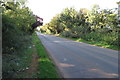
5
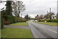
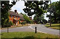
Berry Hill Road approaching West Adderbury
Image: © Roger Templeman
Taken: 12 Apr 2013
0.08 miles
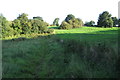
7
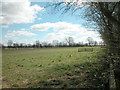
South of Adderbury
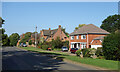
The village of Adderbury is surrounded largely by farmland and a few paddocks.
Image: © Dennis Turner
Taken: 8 Apr 2006
0.18 miles
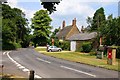
10
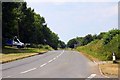
Berry Hill Road heading for Adderbury
Image: © Philip Jeffrey
Taken: 13 Sep 2020
0.24 miles