IMAGES TAKEN NEAR TO
The Leys, BANBURY, OX17 3ES
Introduction
This page details the photographs taken nearby to The Leys, OX17 3ES by members of the Geograph project.
The Geograph project started in 2005 with the aim of publishing, organising and preserving representative images for every square kilometre of Great Britain, Ireland and the Isle of Man.

There are currently over 7.5m images from over14,400 individuals and you can help contribute to the project by visiting https://www.geograph.org.uk
Image Map (Loading...)


Getting Data...Please wait
Leaflet Map data © OpenStreetMap
Images are licensed for reuse under creativecommons.org/licenses/by-sa/2.0
Notes
- Clicking on the map will re-center to the selected point.
- The higher the marker number, the further away the image location is from the centre of the postcode.
Image Listing (61 Images Found)
Images are licensed for reuse under creativecommons.org/licenses/by-sa/2.0
Image
Details
Distance
4
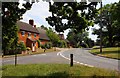
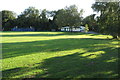
Adderbury
Village three miles south of Banbury and two miles from Bloxham.
Image: © Dennis Turner
Taken: 8 Apr 2006
0.12 miles
5
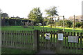
Play area on the Lucy Plackett recreation ground
Image: © Philip Jeffrey
Taken: 13 Sep 2020
0.13 miles
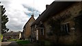
7
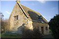
The old Quaker Meeting House in West Adderbury
Image: © Alan Ford
Taken: 16 Dec 2007
0.15 miles
8
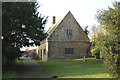
The old Quaker Meeting House in West Adderbury
Image: © Alan Ford
Taken: 16 Dec 2007
0.15 miles