IMAGES TAKEN NEAR TO
Roundtown, BANBURY, OX17 3BH
Introduction
This page details the photographs taken nearby to Roundtown, OX17 3BH by members of the Geograph project.
The Geograph project started in 2005 with the aim of publishing, organising and preserving representative images for every square kilometre of Great Britain, Ireland and the Isle of Man.

There are currently over 7.5m images from over14,400 individuals and you can help contribute to the project by visiting https://www.geograph.org.uk
Image Map
Images are licensed for reuse under creativecommons.org/licenses/by-sa/2.0
Notes
- Clicking on the map will re-center to the selected point.
- The higher the marker number, the further away the image location is from the centre of the postcode.
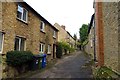
Image Listing (76 Images Found)
Images are licensed for reuse under creativecommons.org/licenses/by-sa/2.0
Image
Details
Distance
3
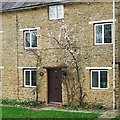
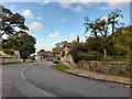
Spring blossom in Aynho
Aynho sometimes known as the Apricot Village many trees are planted along the south facing walls of the cottages.
Image: © michael
Taken: 21 Mar 2011
0.02 miles
4
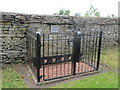
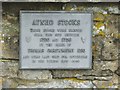
Stocks, Aynho
Used between 1700 and 1726.
Image: © Jonathan Thacker
Taken: 14 Jun 2017
0.03 miles
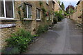
6
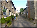
Little Lane in Aynho
Little Lane leads through to The Square.
Image: © Steve Daniels
Taken: 5 Nov 2013
0.03 miles