IMAGES TAKEN NEAR TO
Queen Street, BANBURY, OX17 2NP
Introduction
This page details the photographs taken nearby to Queen Street, OX17 2NP by members of the Geograph project.
The Geograph project started in 2005 with the aim of publishing, organising and preserving representative images for every square kilometre of Great Britain, Ireland and the Isle of Man.

There are currently over 7.5m images from over14,400 individuals and you can help contribute to the project by visiting https://www.geograph.org.uk
Image Map
Images are licensed for reuse under creativecommons.org/licenses/by-sa/2.0
Notes
- Clicking on the map will re-center to the selected point.
- The higher the marker number, the further away the image location is from the centre of the postcode.
Image Listing (64 Images Found)
Images are licensed for reuse under creativecommons.org/licenses/by-sa/2.0
Image
Details
Distance
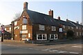
3
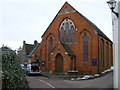
Methodist Church, Middleton Cheney
Situated in Queen Street.
Image: © Cathy Cox
Taken: 1 May 2006
0.06 miles
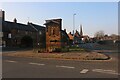
4
Seven Shires Way
Seven Shires Way heads off from Church Lane Middleton Cheney
Image: © Shaun Ferguson
Taken: 17 Jul 2011
0.07 miles
5
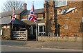
The side entrance to The Dolphin Inn, Middleton Cheney
Image: © David Howard
Taken: 20 Mar 2022
0.07 miles
7
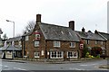
Middleton Cheney-The Dolphin Inn
At the junction of Main Road and High Street.
Image: © Ian Rob
Taken: 11 Dec 2015
0.08 miles
9

Benchmark bracket on Middleton Cheney School
Ordnance Survey flush bracket, serial number 10985, described on the Bench Mark Database at http://www.bench-marks.org.uk/bm22102
Image: © Roger Templeman
Taken: 24 Apr 2013
0.09 miles
10
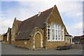
Middleton Cheney School
There is an OS flush bracket benchmark Image on the corner of the jut right of the blocked arch
Image: © Roger Templeman
Taken: 24 Apr 2013
0.09 miles