IMAGES TAKEN NEAR TO
Peveril Road, BANBURY, OX17 2DN
Introduction
This page details the photographs taken nearby to Peveril Road, OX17 2DN by members of the Geograph project.
The Geograph project started in 2005 with the aim of publishing, organising and preserving representative images for every square kilometre of Great Britain, Ireland and the Isle of Man.

There are currently over 7.5m images from over14,400 individuals and you can help contribute to the project by visiting https://www.geograph.org.uk
Image Map
Images are licensed for reuse under creativecommons.org/licenses/by-sa/2.0
Notes
- Clicking on the map will re-center to the selected point.
- The higher the marker number, the further away the image location is from the centre of the postcode.
Image Listing (21 Images Found)
Images are licensed for reuse under creativecommons.org/licenses/by-sa/2.0
Image
Details
Distance

6
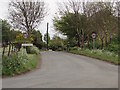
Greatworth village sign
Eastern entrance to the village.
Image: © Duncan Lilly
Taken: 7 May 2007
0.18 miles
8
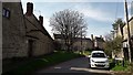
Marston Road, Greatworth
Marston Road gains much of its character from the informal relation of buildings to the road edges and the grass and trees (and daffodils) in the gaps.
Image: © Chris Brown
Taken: 5 Apr 2017
0.19 miles
9
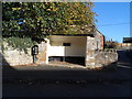
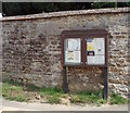
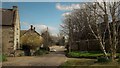
Bus shelter, Greatworth
The plaque says that it was built to commemorate the Queen's coronation in 1953.
Image: © Bikeboy
Taken: 1 Nov 2014
0.19 miles