IMAGES TAKEN NEAR TO
The Green, BANBURY, OX17 2BA
Introduction
This page details the photographs taken nearby to The Green, OX17 2BA by members of the Geograph project.
The Geograph project started in 2005 with the aim of publishing, organising and preserving representative images for every square kilometre of Great Britain, Ireland and the Isle of Man.

There are currently over 7.5m images from over14,400 individuals and you can help contribute to the project by visiting https://www.geograph.org.uk
Image Map
Images are licensed for reuse under creativecommons.org/licenses/by-sa/2.0
Notes
- Clicking on the map will re-center to the selected point.
- The higher the marker number, the further away the image location is from the centre of the postcode.
Image Listing (39 Images Found)
Images are licensed for reuse under creativecommons.org/licenses/by-sa/2.0
Image
Details
Distance
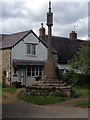

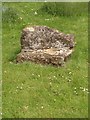
5
War Memorial, Culworth
The base is medieval https://historicengland.org.uk/listing/the-list/list-entry/1371811
Image: © Jonathan Thacker
Taken: 13 Dec 2019
0.02 miles
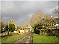
6

Culworth-The Old Forge
Gallery and Shop on High Street.
Image: © Ian Rob
Taken: 7 Jul 2012
0.02 miles
9
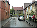
Banbury Lane junction in Culworth
To the right is Queen Street and to the left the High Street of this very pleasant village.
Image: © Stuart Logan
Taken: 28 Apr 2012
0.04 miles
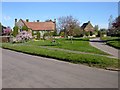
10
The north end of The Green, Culworth
Image: © Jonathan Thacker
Taken: 13 Dec 2019
0.05 miles