IMAGES TAKEN NEAR TO
Sulgrave Road, BANBURY, OX17 2AP
Introduction
This page details the photographs taken nearby to Sulgrave Road, OX17 2AP by members of the Geograph project.
The Geograph project started in 2005 with the aim of publishing, organising and preserving representative images for every square kilometre of Great Britain, Ireland and the Isle of Man.

There are currently over 7.5m images from over14,400 individuals and you can help contribute to the project by visiting https://www.geograph.org.uk
Image Map
Images are licensed for reuse under creativecommons.org/licenses/by-sa/2.0
Notes
- Clicking on the map will re-center to the selected point.
- The higher the marker number, the further away the image location is from the centre of the postcode.
Image Listing (4 Images Found)
Images are licensed for reuse under creativecommons.org/licenses/by-sa/2.0
Image
Details
Distance
3
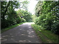
Culworth Around the Corner
This avenue of trees is on the road into Culworth from the east.
Image: © Michael Patterson
Taken: 20 Jun 2006
0.22 miles
4
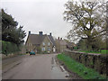
Queens Street
Behind the wall on the right is the cricket ground.
Image: © Stuart Logan
Taken: 28 Apr 2012
0.24 miles