IMAGES TAKEN NEAR TO
Mollington, BANBURY, OX17 1QE
Introduction
This page details the photographs taken nearby to OX17 1QE by members of the Geograph project.
The Geograph project started in 2005 with the aim of publishing, organising and preserving representative images for every square kilometre of Great Britain, Ireland and the Isle of Man.

There are currently over 7.5m images from over14,400 individuals and you can help contribute to the project by visiting https://www.geograph.org.uk
Image Map
Images are licensed for reuse under creativecommons.org/licenses/by-sa/2.0
Notes
- Clicking on the map will re-center to the selected point.
- The higher the marker number, the further away the image location is from the centre of the postcode.
Image Listing (3 Images Found)
Images are licensed for reuse under creativecommons.org/licenses/by-sa/2.0
Image
Details
Distance
1
Seven Shires Way
Seven Shires Way nearing farmhouse on the way to Mollington Road
Image: © Shaun Ferguson
Taken: 19 Jun 2011
0.01 miles
2

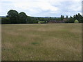
Driveway to Point to Point Farm
As the name suggests, there is a course laid out around the hillsides at this farm and a couple of the fences can just be seen by the hedge in the distance.
Image: © David Stowell
Taken: 29 Mar 2006
0.12 miles
3
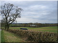
View towards Clattercote Reservoir
Looking east from the lane to Claydon.
Image: © David Stowell
Taken: 29 Mar 2006
0.18 miles