IMAGES TAKEN NEAR TO
Vicarage Gardens, BANBURY, OX17 1PJ
Introduction
This page details the photographs taken nearby to Vicarage Gardens, OX17 1PJ by members of the Geograph project.
The Geograph project started in 2005 with the aim of publishing, organising and preserving representative images for every square kilometre of Great Britain, Ireland and the Isle of Man.

There are currently over 7.5m images from over14,400 individuals and you can help contribute to the project by visiting https://www.geograph.org.uk
Image Map (Loading...)


Getting Data...Please wait
Leaflet Map data © OpenStreetMap
Images are licensed for reuse under creativecommons.org/licenses/by-sa/2.0
Notes
- Clicking on the map will re-center to the selected point.
- The higher the marker number, the further away the image location is from the centre of the postcode.
Image Listing (206 Images Found)
Images are licensed for reuse under creativecommons.org/licenses/by-sa/2.0
Image
Details
Distance
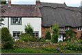
1
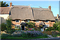
Thatched cottage in the village centre, Cropredy
Image: © Andy F
Taken: 9 Aug 2009
0.03 miles
2
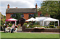
Tea in the garden during festival week, Cropredy
Image: © Andy F
Taken: 16 Aug 2009
0.03 miles
5
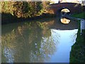
The Oxford Canal, Cropredy
Bridge number 152, which spans the boundary of the grid-square as well as the canal. Through it is Cropredy Lock.
Image: © Andrew Smith
Taken: 12 Jan 2008
0.05 miles
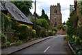
6
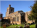
Cropredy Church
Saint Mary The Virgin built in the 14th century.
Image: © Ian Rob
Taken: 24 Oct 2010
0.05 miles
7
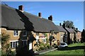
Cropredy-The Red Lion
The Red Lion public house and cottages in Red Lion Street.
Image: © Ian Rob
Taken: 24 Oct 2010
0.05 miles
8
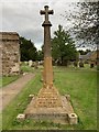
Cropredy War Memorial
In the churchyard.
Image: © Andrew Abbott
Taken: 6 Sep 2020
0.05 miles
10
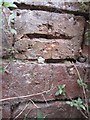
Ordnance Survey Cut Mark
This OS cut mark can be found on the building now used by the Canoe Club. It marks a point 100.4347m above mean sea level.
Image: © Adrian Dust
Taken: 9 Aug 2013
0.06 miles