IMAGES TAKEN NEAR TO
Warmington, BANBURY, OX17 1JL
Introduction
This page details the photographs taken nearby to OX17 1JL by members of the Geograph project.
The Geograph project started in 2005 with the aim of publishing, organising and preserving representative images for every square kilometre of Great Britain, Ireland and the Isle of Man.

There are currently over 7.5m images from over14,400 individuals and you can help contribute to the project by visiting https://www.geograph.org.uk
Image Map
Images are licensed for reuse under creativecommons.org/licenses/by-sa/2.0
Notes
- Clicking on the map will re-center to the selected point.
- The higher the marker number, the further away the image location is from the centre of the postcode.
Image Listing (4 Images Found)
Images are licensed for reuse under creativecommons.org/licenses/by-sa/2.0
Image
Details
Distance
1
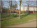
Daff and farm machinery
An colourful mixture seen beside the driveway to the National Herb Centre.
Image: © David Stowell
Taken: 20 Mar 2009
0.17 miles
2
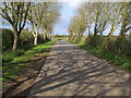
Drive nearing the B4086
Drive from Fir Tree Farm nearing the B4086
Image: © Shaun Ferguson
Taken: 29 Apr 2013
0.18 miles
3
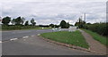
Entrance to National Herb Centre, Warmington
Image: © nick macneill
Taken: 31 Aug 2011
0.19 miles
4
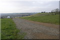
Caravan Site
Fir Tree Farm caravan site perches precariously on the side of this very steep hill.
Image: © Michael Patterson
Taken: 31 Jan 2006
0.22 miles