IMAGES TAKEN NEAR TO
Middle Lane, BANBURY, OX17 1JG
Introduction
This page details the photographs taken nearby to Middle Lane, OX17 1JG by members of the Geograph project.
The Geograph project started in 2005 with the aim of publishing, organising and preserving representative images for every square kilometre of Great Britain, Ireland and the Isle of Man.

There are currently over 7.5m images from over14,400 individuals and you can help contribute to the project by visiting https://www.geograph.org.uk
Image Map
Images are licensed for reuse under creativecommons.org/licenses/by-sa/2.0
Notes
- Clicking on the map will re-center to the selected point.
- The higher the marker number, the further away the image location is from the centre of the postcode.
Image Listing (9 Images Found)
Images are licensed for reuse under creativecommons.org/licenses/by-sa/2.0
Image
Details
Distance
1
Unusual house
Unusual house in Shotteswell.
Image: © Colin Craig
Taken: 9 Oct 2009
0.05 miles
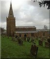
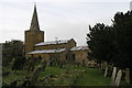
3
St Lawrence's spire, Shotteswell
The steep slope of Church Lane leads from outside the village hall towards St Lawrence's church, parts of which date from the 13th century. The buildings in view are all of the local ironstone. The road sign on the left warns of frogs or toads!
Image: © E Gammie
Taken: 24 Oct 2010
0.09 miles
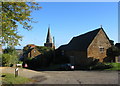
4
Shotteswell Churchyard
Saint Lawrence towers above the surrounding countryside.
Image: © Ian Rob
Taken: 18 Apr 2014
0.09 miles
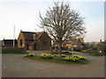
5
Shotteswell
The daffodils are out and the colours blend well with the gingerbread of the ironstone village buildings in the early evening light.
Image: © David Stowell
Taken: 20 Mar 2009
0.10 miles
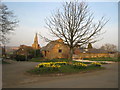
6
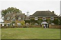
Shotteswell Green and Village Hall
Looking across the daffodils on the small green towards the village hall in the early evening light on the day of the vernal equinox.
Image: © David Stowell
Taken: 20 Mar 2009
0.10 miles
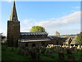
7
St Laurence Shotteswell
St Laurence Church Shotteswell is one of many ironstone churches in this area. See also Image,Image, Image
Image: © Michael Patterson
Taken: 31 Jan 2006
0.13 miles
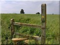
9
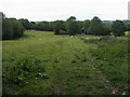
Seven Shires Way
Off Bakehouse Lane the footpath part of Seven Shires Way heading to the M40 footbridge
Image: © Shaun Ferguson
Taken: 19 Jun 2011
0.21 miles