IMAGES TAKEN NEAR TO
Ivy Lane, BANBURY, OX17 1FF
Introduction
This page details the photographs taken nearby to Ivy Lane, OX17 1FF by members of the Geograph project.
The Geograph project started in 2005 with the aim of publishing, organising and preserving representative images for every square kilometre of Great Britain, Ireland and the Isle of Man.

There are currently over 7.5m images from over14,400 individuals and you can help contribute to the project by visiting https://www.geograph.org.uk
Image Map
Images are licensed for reuse under creativecommons.org/licenses/by-sa/2.0
Notes
- Clicking on the map will re-center to the selected point.
- The higher the marker number, the further away the image location is from the centre of the postcode.
Image Listing (41 Images Found)
Images are licensed for reuse under creativecommons.org/licenses/by-sa/2.0
Image
Details
Distance
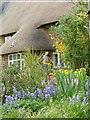
1
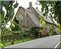
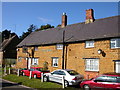
Thatched cottages, Mollington
17th century thatched cottages
Image: © Peter Jones
Taken: 13 Jul 2004
0.03 miles
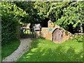
2
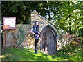
Mollington-All Saints Church
A very small door to a very small stone building at the churchyard entrance.
Image: © Ian Rob
Taken: 24 Oct 2010
0.03 miles
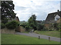
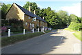
4
The Old Chapel, Mollington
Primitive Methodist chapel now a private house.
Image: © Peter Jones
Taken: 7 Jun 2005
0.07 miles
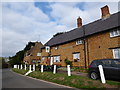
6
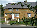
Green Man Inn, Mollington
17th century pub
Image: © Peter Jones
Taken: 28 Jul 2004
0.07 miles
7
The jetty, Mollington
17th century thatched cottage
Image: © Peter Jones
Taken: 2 May 2004
0.07 miles
8
Mollington-The Green Man
Public House on Main Street.
Image: © Ian Rob
Taken: 24 Oct 2010
0.07 miles
9
The Green Man, Mollington: late August 2016
Image: © Basher Eyre
Taken: 31 Aug 2016
0.07 miles