IMAGES TAKEN NEAR TO
Mollington, BANBURY, OX17 1AY
Introduction
This page details the photographs taken nearby to OX17 1AY by members of the Geograph project.
The Geograph project started in 2005 with the aim of publishing, organising and preserving representative images for every square kilometre of Great Britain, Ireland and the Isle of Man.

There are currently over 7.5m images from over14,400 individuals and you can help contribute to the project by visiting https://www.geograph.org.uk
Image Map
Images are licensed for reuse under creativecommons.org/licenses/by-sa/2.0
Notes
- Clicking on the map will re-center to the selected point.
- The higher the marker number, the further away the image location is from the centre of the postcode.
Image Listing (37 Images Found)
Images are licensed for reuse under creativecommons.org/licenses/by-sa/2.0
Image
Details
Distance
3
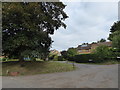
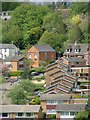
Mollington-Lower Farm Lane
View from School Hill.
Image: © Ian Rob
Taken: 16 Jul 2019
0.09 miles
5
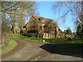
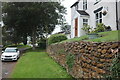
The Old School Mollington
Old Victorian School Mollington, now a private house.In 1911 it had 66 pupils!!!!!
Image: © Peter Jones
Taken: 20 Jan 2006
0.10 miles
6
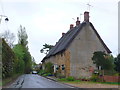
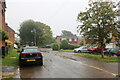
Houses in Mollington
This row of stone thatched cottages is built out of the local honey coloured stone typical of the cotswolds.
Image: © Nigel Mykura
Taken: 12 May 2013
0.12 miles
7
The Old Chapel, Mollington
Primitive Methodist chapel now a private house.
Image: © Peter Jones
Taken: 7 Jun 2005
0.13 miles
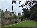
10
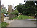
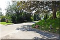
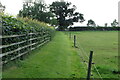
Seven Shires Way
From Church lane the Seven Shires Way passes through All Saints Church Mollington
Image: © Shaun Ferguson
Taken: 19 Jun 2011
0.16 miles