IMAGES TAKEN NEAR TO
Edgcote, BANBURY, OX17 1AG
Introduction
This page details the photographs taken nearby to OX17 1AG by members of the Geograph project.
The Geograph project started in 2005 with the aim of publishing, organising and preserving representative images for every square kilometre of Great Britain, Ireland and the Isle of Man.

There are currently over 7.5m images from over14,400 individuals and you can help contribute to the project by visiting https://www.geograph.org.uk
Image Map (Loading...)


Getting Data...Please wait
Leaflet Map data © OpenStreetMap
Images are licensed for reuse under creativecommons.org/licenses/by-sa/2.0
Notes
- Clicking on the map will re-center to the selected point.
- The higher the marker number, the further away the image location is from the centre of the postcode.
Image Listing (10 Images Found)
Images are licensed for reuse under creativecommons.org/licenses/by-sa/2.0
Image
Details
Distance
3
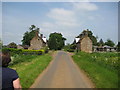
The Jurassic Way past Edgcote Drive Cottages
These look like 'estate' buildings
Image: © Tim Heaton
Taken: 26 May 2012
0.07 miles
4
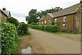
Edgcote
At the junction with the road to Wardington.
Image: © Ian Rob
Taken: 21 Jun 2006
0.11 miles
5
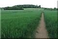
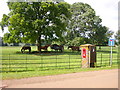
Jurassic Way climbing up to Ladshill Spinney
Image: © Philip Jeffrey
Taken: 22 May 2022
0.13 miles
6

Footpath down to the river, and sewage works
Image: © Philip Jeffrey
Taken: 22 May 2022
0.20 miles
7
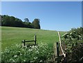
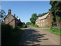
The Jurassic Way towards Ladshill Spinney
Image: © Tim Heaton
Taken: 26 May 2012
0.23 miles
8
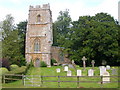
Edgcote Church
Church dedicated to Saint James next to Edgcote House.
Image: © Ian Rob
Taken: 21 Jun 2006
0.24 miles
9
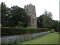
Edgcote Church Tower
Looking at Saint James Church Tower from Jurassic Way.
Image: © Ian Rob
Taken: 5 Jun 2010
0.24 miles
