IMAGES TAKEN NEAR TO
Bidwell Road, BANBURY, OX16 9ZL
Introduction
This page details the photographs taken nearby to Bidwell Road, OX16 9ZL by members of the Geograph project.
The Geograph project started in 2005 with the aim of publishing, organising and preserving representative images for every square kilometre of Great Britain, Ireland and the Isle of Man.

There are currently over 7.5m images from over14,400 individuals and you can help contribute to the project by visiting https://www.geograph.org.uk
Image Map (Loading...)


Getting Data...Please wait
Leaflet Map data © OpenStreetMap
Images are licensed for reuse under creativecommons.org/licenses/by-sa/2.0
Notes
- Clicking on the map will re-center to the selected point.
- The higher the marker number, the further away the image location is from the centre of the postcode.
Image Listing (17 Images Found)
Images are licensed for reuse under creativecommons.org/licenses/by-sa/2.0
Image
Details
Distance
1
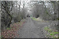
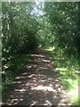
Salt Way
An ancient right of way. Most of its length seems to have a wooded screen each side.
Image: © Bill Boaden
Taken: 24 Jan 2022
0.08 miles
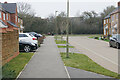
2

Tyrrell Road
Part of the new Bloxham Vale housing development.
Image: © Bill Boaden
Taken: 24 Jan 2022
0.11 miles
3
Adams Close
Part of the new Bloxham Vale housing development. This is also the route of a pre-existing public footpath which links up with the Salt Way.
Image: © Bill Boaden
Taken: 24 Jan 2022
0.11 miles
4
Crouch Hill
Viewed here from the Salt Way. The hill sticks up above all the surrounding countryside.
Image: © Bill Boaden
Taken: 24 Jan 2022
0.13 miles
5
Benchmark on #2 Crouch Cottages
Ordnance Survey cut mark benchmark described on the Bench Mark Database at http://www.bench-marks.org.uk/bm57359
Image: © Roger Templeman
Taken: 16 May 2014
0.15 miles
6
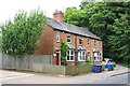
Crouch Cottages, Bloxham Road
There is an OS benchmark Image on the side of the left hand cottage at its front corner where a wooden fence abuts
Image: © Roger Templeman
Taken: 16 May 2014
0.15 miles
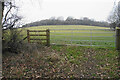
7
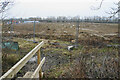
The next field lined up for housing expansion
The Bloxham Vale housing development will spread from the left across this field.
Image: © Bill Boaden
Taken: 24 Jan 2022
0.17 miles
8

Traffic lights on Bloxham Road
Temporary traffic lights on the A361 while a roundabout is developed giving access to the new Bloxham Vale housing development to the right. This is now the edge of the Banbury conurbation.
Image: © Bill Boaden
Taken: 24 Jan 2022
0.17 miles
10
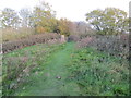
Path, Woodland and Triangulation Pillar on top of Crouch Hill
Looking eastward.
Image: © Peter Wood
Taken: 5 Nov 2017
0.19 miles