IMAGES TAKEN NEAR TO
Wykham Lane, BANBURY, OX16 9UR
Introduction
This page details the photographs taken nearby to Wykham Lane, OX16 9UR by members of the Geograph project.
The Geograph project started in 2005 with the aim of publishing, organising and preserving representative images for every square kilometre of Great Britain, Ireland and the Isle of Man.

There are currently over 7.5m images from over14,400 individuals and you can help contribute to the project by visiting https://www.geograph.org.uk
Image Map (Loading...)


Getting Data...Please wait
Leaflet Map data © OpenStreetMap
Images are licensed for reuse under creativecommons.org/licenses/by-sa/2.0
Notes
- Clicking on the map will re-center to the selected point.
- The higher the marker number, the further away the image location is from the centre of the postcode.
Image Listing (15 Images Found)
Images are licensed for reuse under creativecommons.org/licenses/by-sa/2.0
Image
Details
Distance
1
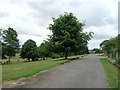
Main driveway, Tudor Hall School
Towards the end of the main driveway in front of the Old House and Main Building.
Image: © David P Howard
Taken: 7 Aug 2010
0.02 miles
2
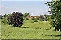
Wykham Park House
A view of the house and parkland
Image: © Robert Caldicott
Taken: 1 Jun 2007
0.02 miles
3
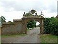
Stone arch on main driveway, Tudor Hall School
Just before the driveway passes the Old House on the right.
Image: © David P Howard
Taken: 7 Aug 2010
0.05 miles
4
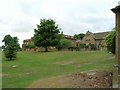
The Main Building, Tudor Hall School
The Main Building and to the right the Old House.
Image: © David P Howard
Taken: 7 Aug 2010
0.06 miles
5

The MacNicol Dining Hall, Tudor Hall School
A very striking circular building in the middle of the school campus.
Image: © David P Howard
Taken: 7 Aug 2010
0.07 miles
6

The Music School, Tudor Hall School
The Music School was opened by Sir Geraint Evans on 28th. November 1986.
Image: © David P Howard
Taken: 7 Aug 2010
0.13 miles
7
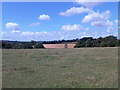
Fields east of A361
The A361 is marked by the line of trees in the middle distance.
Image: © David P Howard
Taken: 3 Aug 2013
0.14 miles
8

All weather Astroturf, Tudor Hall School
View across the all weather playing area towards some school houses. From left to right, Todd House, Sanfine House and Staff Cottage.
Image: © David P Howard
Taken: 7 Aug 2010
0.16 miles
9
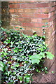
Benchmark on Wykham Lane bridge
Ordnance Survey cut mark benchmark described on the Bench Mark Database at http://www.bench-marks.org.uk/bm57583
Image: © Roger Templeman
Taken: 16 May 2014
0.18 miles
10
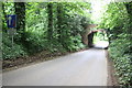
Bridge over Wykham Lane
The bridge carries an access road to Carrdus School and has an OS benchmark Image on the face towards the camera on the left hand side of the arch
Image: © Roger Templeman
Taken: 16 May 2014
0.18 miles