IMAGES TAKEN NEAR TO
Bankside, BANBURY, OX16 9SX
Introduction
This page details the photographs taken nearby to Bankside, OX16 9SX by members of the Geograph project.
The Geograph project started in 2005 with the aim of publishing, organising and preserving representative images for every square kilometre of Great Britain, Ireland and the Isle of Man.

There are currently over 7.5m images from over14,400 individuals and you can help contribute to the project by visiting https://www.geograph.org.uk
Image Map (Loading...)


Getting Data...Please wait
Leaflet Map data © OpenStreetMap
Images are licensed for reuse under creativecommons.org/licenses/by-sa/2.0
Notes
- Clicking on the map will re-center to the selected point.
- The higher the marker number, the further away the image location is from the centre of the postcode.
Image Listing (36 Images Found)
Images are licensed for reuse under creativecommons.org/licenses/by-sa/2.0
Image
Details
Distance
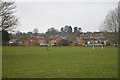
2
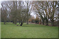
Bankside Park
The Oxford Canal forms the northern margins - hence the name.
Image: © Fernweh
Taken: 9 Mar 2013
0.04 miles
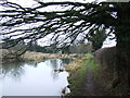
5
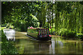
Oxford Canal, Banbury
A hire-fleet narrowboat approaches Banbury from the south through a tunnel of trees.
Image: © Stephen McKay
Taken: 8 Jun 2014
0.08 miles
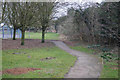
6
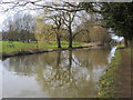
Oxford Canal Walk
Oxford Canal Walk passing Bankside Park
Image: © Shaun Ferguson
Taken: 25 Mar 2016
0.08 miles
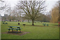
8
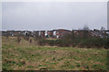
Houses with a view
Houses along Bankside looking out over the Cherwell valley and the Oxford Canal.
Image: © Fernweh
Taken: 9 Mar 2013
0.10 miles
9

Former lift bridge foundations
On the Oxford Canal
Image: © Andrew Abbott
Taken: 7 Sep 2020
0.10 miles
10
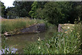
Oxford canal, missing bridge
Presumably, this was bridge 169
Image: © Robert Eva
Taken: 23 Jun 2018
0.10 miles