IMAGES TAKEN NEAR TO
Boundary Way, OX16 9NN
Introduction
This page details the photographs taken nearby to Boundary Way, OX16 9NN by members of the Geograph project.
The Geograph project started in 2005 with the aim of publishing, organising and preserving representative images for every square kilometre of Great Britain, Ireland and the Isle of Man.

There are currently over 7.5m images from over14,400 individuals and you can help contribute to the project by visiting https://www.geograph.org.uk
Image Map (Loading...)


Getting Data...Please wait
Leaflet Map data © OpenStreetMap
Images are licensed for reuse under creativecommons.org/licenses/by-sa/2.0
Notes
- Clicking on the map will re-center to the selected point.
- The higher the marker number, the further away the image location is from the centre of the postcode.
Image Listing (7 Images Found)
Images are licensed for reuse under creativecommons.org/licenses/by-sa/2.0
Image
Details
Distance
1
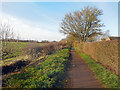
Salt Way, Bodicote
A bridle path and cycleway which for the time being marks the boundary between suburban Banbury and farmland round Bodicote. The name suggests it might be an ancient route.
Image: © Des Blenkinsopp
Taken: 17 Dec 2018
0.11 miles
2
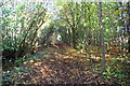
Tree-lined footpath towards Banbury
Image: © Roger Templeman
Taken: 27 Oct 2017
0.16 miles
4
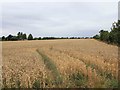
Field next to allotments near Bodicote
Looking NNW across the wheat field next to the allotments, opposite Bodicote Cemetery.
Image: © David P Howard
Taken: 6 Aug 2011
0.20 miles
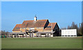
5
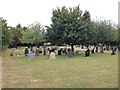
Bodicote Cemetery
Hours of admission are 9.00 am to sunset. Administered by Bodicote Parish Council.
Image: © David P Howard
Taken: 6 Aug 2011
0.24 miles
6
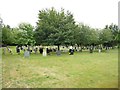
Bodicote Cemetery
This is an over the same wall repeat of David's Image It's pleasing to report that there were no new graves in the area photographed. The Cemetery is on Wykham Lane and is a comparatively recent rectangular offtake of the field that surrounds it. Both the current Ordnance Survey 1:25,000 and 1:50,000 scale maps show it but with a squarer shape and not quite in the correct place, so maybe it has been extended westwards from its original location.
Image: © Nigel Cox
Taken: 27 Jul 2015
0.24 miles
7
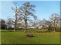
Bench in the Park, Bodicote
Very little separates Bodicote village from southern Banbury. Just here it is only this small park that comes between the two.
Image: © Des Blenkinsopp
Taken: 17 Dec 2018
0.25 miles