IMAGES TAKEN NEAR TO
Cranleigh Close, BANBURY, OX16 9NJ
Introduction
This page details the photographs taken nearby to Cranleigh Close, OX16 9NJ by members of the Geograph project.
The Geograph project started in 2005 with the aim of publishing, organising and preserving representative images for every square kilometre of Great Britain, Ireland and the Isle of Man.

There are currently over 7.5m images from over14,400 individuals and you can help contribute to the project by visiting https://www.geograph.org.uk
Image Map (Loading...)


Getting Data...Please wait
Leaflet Map data © OpenStreetMap
Images are licensed for reuse under creativecommons.org/licenses/by-sa/2.0
Notes
- Clicking on the map will re-center to the selected point.
- The higher the marker number, the further away the image location is from the centre of the postcode.
Image Listing (33 Images Found)
Images are licensed for reuse under creativecommons.org/licenses/by-sa/2.0
Image
Details
Distance
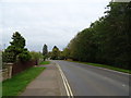
2
Brantwood Rise, Banbury
Viewed from the Queensway end. Queensway Primary School entrance http://www.geograph.org.uk/photo/4212410 is on the right.
Image: © Jaggery
Taken: 18 Oct 2014
0.12 miles
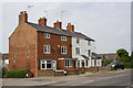
3
Houses on Broughton Road, Banbury
Showing position of Postbox No. OX16 1112.
See Image] for postbox.
Image: © JThomas
Taken: 5 Oct 2019
0.13 miles
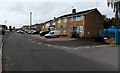
4
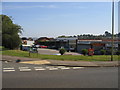
Local Shops
The small 1960s shopping precinct at the junction of Mewburn Road and the Queensway, Banbury.
Image: © David Stowell
Taken: 10 Sep 2006
0.14 miles
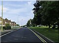
5
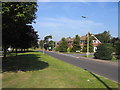
Queensway, Banbury
Near the junction with Burlington Gardens.
Image: © David Stowell
Taken: 10 Sep 2006
0.14 miles
6
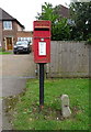
Elizabeth II postbox on Broughton Road, Banbury
Postbox No. OX16 1112.
See Image] for context.
Image: © JThomas
Taken: 5 Oct 2019
0.14 miles
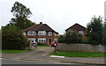
7
Broughton Road houses at Claypits Close junction
There is an OS benchmark Image on the Claypits Close face of the nearest house just left of the grey downpipe
Image: © Roger Templeman
Taken: 16 May 2014
0.15 miles
8
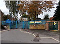
Queensway Primary School entrance, Banbury
From Brantwood Rise, near the corner of Queensway.
The identifier on the Central Networks electricity substation on the right is
BRANTWOOD RISE H.V. SUBSTATION 0701099.
Image: © Jaggery
Taken: 18 Oct 2014
0.15 miles
9
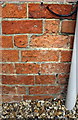
Benchmark on #292 Broughton Road
Ordnance Survey cut mark benchmark described on the Bench Mark Database at http://www.bench-marks.org.uk/bm57585
Image: © Roger Templeman
Taken: 16 May 2014
0.15 miles