IMAGES TAKEN NEAR TO
The Hawthorns, BANBURY, OX16 9FA
Introduction
This page details the photographs taken nearby to The Hawthorns, OX16 9FA by members of the Geograph project.
The Geograph project started in 2005 with the aim of publishing, organising and preserving representative images for every square kilometre of Great Britain, Ireland and the Isle of Man.

There are currently over 7.5m images from over14,400 individuals and you can help contribute to the project by visiting https://www.geograph.org.uk
Image Map
Images are licensed for reuse under creativecommons.org/licenses/by-sa/2.0
Notes
- Clicking on the map will re-center to the selected point.
- The higher the marker number, the further away the image location is from the centre of the postcode.
Image Listing (29 Images Found)
Images are licensed for reuse under creativecommons.org/licenses/by-sa/2.0
Image
Details
Distance
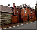
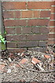
1
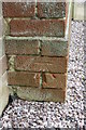
Benchmark on police office, Oxford Road
Ordnance Survey cut mark benchmark described on the Bench Mark Database at http://www.bench-marks.org.uk/bm57129
Image: © Roger Templeman
Taken: 29 Apr 2014
0.13 miles
2
Oxfordshire Constabulary building Grange Road
There is an OS benchmark Image on the side of the building where the brick wall abuts
Image: © Roger Templeman
Taken: 29 Apr 2014
0.13 miles

7
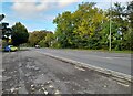
View along Hightown Road from beside garage of #55
There is an OS benchmark Image at the base of the wall pier at left hand edge of the image
Image: © Roger Templeman
Taken: 29 Apr 2014
0.20 miles
8
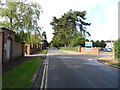
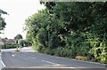
Hightown Road, Banbury
An entrance to the Horton General Hospital on the right.
Image: © JThomas
Taken: 28 Sep 2019
0.20 miles
9
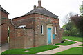
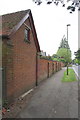
The Coach House, Banbury
The Coach House at 61 Hightown Road is the office of David J Stewart Associates, chartered architects.
Image: © Jaggery
Taken: 18 Oct 2014
0.20 miles
10
Benchmark on garage of #55 Hightown Road
Ordnance Survey cut mark benchmark described on the Bench Mark Database at http://www.bench-marks.org.uk/bm57125
Image: © Roger Templeman
Taken: 29 Apr 2014
0.20 miles