IMAGES TAKEN NEAR TO
Hightown Road, BANBURY, OX16 9BT
Introduction
This page details the photographs taken nearby to Hightown Road, OX16 9BT by members of the Geograph project.
The Geograph project started in 2005 with the aim of publishing, organising and preserving representative images for every square kilometre of Great Britain, Ireland and the Isle of Man.

There are currently over 7.5m images from over14,400 individuals and you can help contribute to the project by visiting https://www.geograph.org.uk
Image Map (Loading...)


Getting Data...Please wait
Leaflet Map data © OpenStreetMap
Images are licensed for reuse under creativecommons.org/licenses/by-sa/2.0
Notes
- Clicking on the map will re-center to the selected point.
- The higher the marker number, the further away the image location is from the centre of the postcode.
Image Listing (119 Images Found)
Images are licensed for reuse under creativecommons.org/licenses/by-sa/2.0
Image
Details
Distance

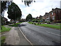
3
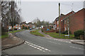
Hightown Road, Banbury
Viewed from opposite the Lime Avenue junction. http://www.geograph.org.uk/photo/4213123
Image: © Jaggery
Taken: 18 Oct 2014
0.03 miles
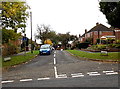
4
Hightown Road
Close to the canal railway station and Horton General Hospital the road joins Swan Close Road with Oxford Road.
Image: © Dennis Turner
Taken: 28 Aug 2012
0.03 miles
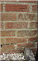
5
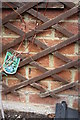
Benchmark behind trellis on side of #56 Hightown Road
Ordnance Survey cut mark benchmark described on the Bench Mark Database at http://www.bench-marks.org.uk/bm57126
Image: © Roger Templeman
Taken: 29 Apr 2014
0.04 miles
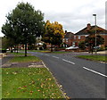
7
Lime Avenue, Banbury
The NW end of a 120 metre long cul-de-sac viewed across Hightown Road.
Image: © Jaggery
Taken: 18 Oct 2014
0.04 miles
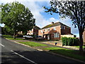
8
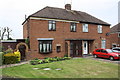
Nos. 54 and 56 Hightown Road
There is an OS benchmark Image on the side of the left hand house just through the brick arch and behind a trellis
Image: © Roger Templeman
Taken: 29 Apr 2014
0.04 miles
9
Benchmark on #19 Hightown Road
Ordnance Survey cut mark benchmark described on the Bench Mark Database at http://www.bench-marks.org.uk/bm57128
Image: © Roger Templeman
Taken: 29 Apr 2014
0.04 miles
10
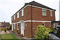
Semis at Hightown Road (#19) / Western Crescent (#2) junction
There is an OS benchmark Image on the side of the near house at its front corner left of the black downpipe
Image: © Roger Templeman
Taken: 29 Apr 2014
0.04 miles