IMAGES TAKEN NEAR TO
Bridge Street, BANBURY, OX16 5QF
Introduction
This page details the photographs taken nearby to Bridge Street, OX16 5QF by members of the Geograph project.
The Geograph project started in 2005 with the aim of publishing, organising and preserving representative images for every square kilometre of Great Britain, Ireland and the Isle of Man.

There are currently over 7.5m images from over14,400 individuals and you can help contribute to the project by visiting https://www.geograph.org.uk
Image Map
Images are licensed for reuse under creativecommons.org/licenses/by-sa/2.0
Notes
- Clicking on the map will re-center to the selected point.
- The higher the marker number, the further away the image location is from the centre of the postcode.
Image Listing (757 Images Found)
Images are licensed for reuse under creativecommons.org/licenses/by-sa/2.0
Image
Details
Distance
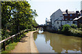
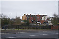
3
Building by Oxford canal
Entering Banbury from the east.
Image: © Fernweh
Taken: 30 Mar 2015
0.01 miles


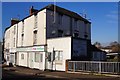
9
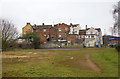
Back of properties on Bridge Street
This small triangle of land lies behind the row of properties on Bridge Street, bounded by Cherwell Street on the right and the Oxford Canal on the left.
It includes a basketball court.
Image: © David P Howard
Taken: 9 Mar 2013
0.01 miles