IMAGES TAKEN NEAR TO
Castle Street, BANBURY, OX16 5NX
Introduction
This page details the photographs taken nearby to Castle Street, OX16 5NX by members of the Geograph project.
The Geograph project started in 2005 with the aim of publishing, organising and preserving representative images for every square kilometre of Great Britain, Ireland and the Isle of Man.

There are currently over 7.5m images from over14,400 individuals and you can help contribute to the project by visiting https://www.geograph.org.uk
Image Map
Images are licensed for reuse under creativecommons.org/licenses/by-sa/2.0
Notes
- Clicking on the map will re-center to the selected point.
- The higher the marker number, the further away the image location is from the centre of the postcode.
Image Listing (891 Images Found)
Images are licensed for reuse under creativecommons.org/licenses/by-sa/2.0
Image
Details
Distance
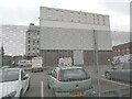
1
Banbury Cross Telephone Exchange, Banbury
View from Cherwell Drive.
Image: © Jaggery
Taken: 18 Oct 2014
0.03 miles
2
Interesting Shop, Banbury
Corn Cake, Forage Seeds, Coal, Coke, Cake, Forage etc. have been sold in this shop.
Image: © Christine Matthews
Taken: 9 Mar 2013
0.03 miles
3
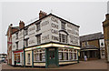
Interesting Shop, Banbury
Corn Cake, Forage Seeds, Coal, Coke, Cake, Forage etc. have been sold in this shop.
Image: © Christine Matthews
Taken: 9 Mar 2013
0.03 miles
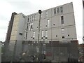
4
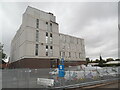
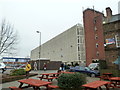
Banbury Telephone Exchange (1)
This large building is situated in Castle Street, although this view is from Cherwell Drive. The wording on the building says "BANBURY CROSS TELEPHONE EXCHANGE" as it replaced the former TE at 49-50 High Street, where The Exchange pub is now located, SP4540 refers. Several Openreach vehicles are parked in front of this TE.
Image: © David Hillas
Taken: 7 Oct 2021
0.03 miles
5
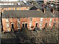
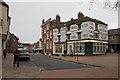
Castle Street
The East end of Castle Street, as viewed from the top of the multi-storey car park opposite.
Image: © Snidge
Taken: 3 Feb 2007
0.04 miles
6
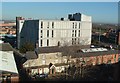
BT Building
The BT building dwarfs the house and buildings behind Castle Street.
Image: © Snidge
Taken: 3 Feb 2007
0.04 miles
7
Bolton Road Car Park
Grade II listed (no only kidding)
Image: © David Lally
Taken: 9 Mar 2013
0.04 miles
8
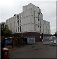
Banbury Telephone Exchange (2)
This photo is of the north side of the TE taken from Bluecoat Close. It has the code SMBB and provides telephone and broadband services to approximately 19,683 residential and 1,310 non-residential premises in Banbury plus Bodicote, Broughton and Nethercote nearby.
Image: © David Hillas
Taken: 7 Oct 2021
0.04 miles
9
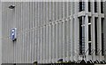
Banbury Telephone Exchange (3)
Taken from Rope Walk, this building is the main one for the (01295) group of thirteen TEs, and has the postcode OX16 5PE. Several cable drums can be seen behind the fence, presumably for use underground between the TE and the green cabinet boxes by the roads.
Image: © David Hillas
Taken: 7 Oct 2021
0.04 miles