IMAGES TAKEN NEAR TO
Christchurch Court, BANBURY, OX16 5DT
Introduction
This page details the photographs taken nearby to Christchurch Court, OX16 5DT by members of the Geograph project.
The Geograph project started in 2005 with the aim of publishing, organising and preserving representative images for every square kilometre of Great Britain, Ireland and the Isle of Man.

There are currently over 7.5m images from over14,400 individuals and you can help contribute to the project by visiting https://www.geograph.org.uk
Image Map
Images are licensed for reuse under creativecommons.org/licenses/by-sa/2.0
Notes
- Clicking on the map will re-center to the selected point.
- The higher the marker number, the further away the image location is from the centre of the postcode.
Image Listing (957 Images Found)
Images are licensed for reuse under creativecommons.org/licenses/by-sa/2.0
Image
Details
Distance
1
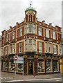
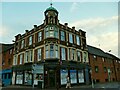
Old co-operative society building
Now a lighting shop
Image: © Duncan Lilly
Taken: 17 May 2007
0.01 miles
2
Old Co-operative Society building
The words "Co-operative Society" can be seen in the brickwork
Image: © Duncan Lilly
Taken: 17 May 2007
0.01 miles
3
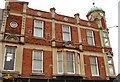
New Management at the old Co-op
A survivor from more stylish days, complete with clock turret and Co Operative Society picked out in brickwork along the frontage.
Hard to see what's in there now with all those adverts in the windows. A few years ago it was a lighting shop. Image
Image: © Des Blenkinsopp
Taken: 17 Dec 2018
0.01 miles
4
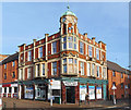
Former Co-Operative store, Broad Street, Banbury
An online article of the Banbury Historical Society https://www.banburyhistoricalsociety.org/uploads/pdf/17/17-02.pdf dates this building to 1907. The corner store has had various uses since its original one, see Image It is now a MACE convenience store, perhaps closest to its builders' intentions.
Image: © Stephen Craven
Taken: 18 Sep 2021
0.01 miles
6
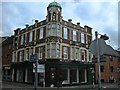
Banbury Co-operative Buildings
On the corner of Broad Street and George Street, the ground floor is empty at present.
Image: © Ian Rob
Taken: 30 Aug 2010
0.02 miles
7
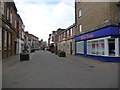
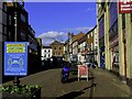
Broad Street, Banbury
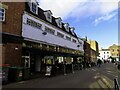
A pedestrian street near the town centre. Not very busy, with quite a few shops closed down. All the shopping action in Banbury seems to be in the big Castle Quay mall, to the detriment of the rest of the downtown area.
Image: © Des Blenkinsopp
Taken: 17 Dec 2018
0.03 miles
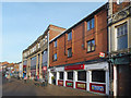
9
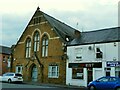
Oriel House, Broad Street, Banbury
This is marked on an early C20 map as 'School LB' (Local Board?). Other online references describe it as the hall associated with Christ Church (a nonconformist church across the road, no longer extant). It has now been converted to apartments.
Image: © Stephen Craven
Taken: 18 Sep 2021
0.04 miles