IMAGES TAKEN NEAR TO
Lower Cherwell Street, BANBURY, OX16 5AJ
Introduction
This page details the photographs taken nearby to Lower Cherwell Street, OX16 5AJ by members of the Geograph project.
The Geograph project started in 2005 with the aim of publishing, organising and preserving representative images for every square kilometre of Great Britain, Ireland and the Isle of Man.

There are currently over 7.5m images from over14,400 individuals and you can help contribute to the project by visiting https://www.geograph.org.uk
Image Map
Images are licensed for reuse under creativecommons.org/licenses/by-sa/2.0
Notes
- Clicking on the map will re-center to the selected point.
- The higher the marker number, the further away the image location is from the centre of the postcode.
Image Listing (562 Images Found)
Images are licensed for reuse under creativecommons.org/licenses/by-sa/2.0
Image
Details
Distance
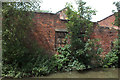
4
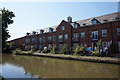
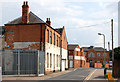
Old Buildings by the Canal
The Oxford Canal coming into Banbury from the south.
Image: © Des Blenkinsopp
Taken: 17 Dec 2018
0.02 miles
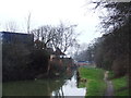
6
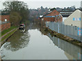
Oxford Canal, Banbury
Near the railway station and taken after the meet for Geograph's 8th birthday.
Image: © Chris Allen
Taken: 9 Mar 2013
0.03 miles
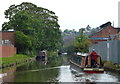
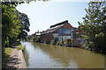
8

Driftweed on the Oxford Canal
A 55ft narrowboat built by Concoform Marine.
Image: © Andrew Abbott
Taken: 7 Sep 2020
0.04 miles
9
Former lift bridge foundations
On the Oxford Canal in Banbury.
Image: © Andrew Abbott
Taken: 7 Sep 2020
0.04 miles
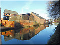
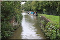
10
Dereliction by the Oxford canal Banbury
Image: © Robert Eva
Taken: 23 Jun 2018
0.04 miles