IMAGES TAKEN NEAR TO
Overfield, Thorpe Way, BANBURY, OX16 4XR
Introduction
This page details the photographs taken nearby to Overfield, Thorpe Way, OX16 4XR by members of the Geograph project.
The Geograph project started in 2005 with the aim of publishing, organising and preserving representative images for every square kilometre of Great Britain, Ireland and the Isle of Man.

There are currently over 7.5m images from over14,400 individuals and you can help contribute to the project by visiting https://www.geograph.org.uk
Image Map
Images are licensed for reuse under creativecommons.org/licenses/by-sa/2.0
Notes
- Clicking on the map will re-center to the selected point.
- The higher the marker number, the further away the image location is from the centre of the postcode.
Image Listing (4 Images Found)
Images are licensed for reuse under creativecommons.org/licenses/by-sa/2.0
Image
Details
Distance
1
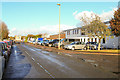
Thorpe Way Industrial Estate, Banbury
Light industrial units on this industrial estate.
Image: © Mike Dodman
Taken: 10 Nov 2016
0.08 miles
2
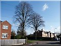
Mature trees, Grimsbury
At the junction of Howard Road and The Causeway.
Image: © Christine Johnstone
Taken: 30 Mar 2015
0.22 miles
3
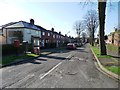
Mid 1900s housing in Edward Street, Grimsbury
Running south from The Causeway. Probably built as social housing.
Image: © Christine Johnstone
Taken: 30 Mar 2015
0.22 miles
4

European base for the American Haas F1 team
Although officially an American team, Haas F1 also have this factory in Banbury.
Image: © Mike Dodman
Taken: 10 Nov 2016
0.24 miles