IMAGES TAKEN NEAR TO
Fulwell Close, BANBURY, OX16 4TF
Introduction
This page details the photographs taken nearby to Fulwell Close, OX16 4TF by members of the Geograph project.
The Geograph project started in 2005 with the aim of publishing, organising and preserving representative images for every square kilometre of Great Britain, Ireland and the Isle of Man.

There are currently over 7.5m images from over14,400 individuals and you can help contribute to the project by visiting https://www.geograph.org.uk
Image Map
Images are licensed for reuse under creativecommons.org/licenses/by-sa/2.0
Notes
- Clicking on the map will re-center to the selected point.
- The higher the marker number, the further away the image location is from the centre of the postcode.
Image Listing (165 Images Found)
Images are licensed for reuse under creativecommons.org/licenses/by-sa/2.0
Image
Details
Distance
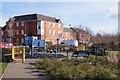
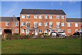
3
Houses along Alma Road
Over looking a communal park and play area.
Image: © Fernweh
Taken: 30 Mar 2015
0.12 miles
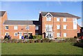
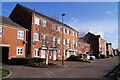
4
Housing off Alma Road
The building in the far distance is the relatively new East carpark at Banbury station.
Image: © Fernweh
Taken: 30 Mar 2015
0.12 miles
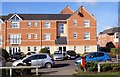
5
Housing off Alma Road
View from communal park.
Image: © Fernweh
Taken: 30 Mar 2015
0.12 miles
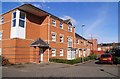
6
Housing off Alma Road
Over looking a communal park and play area.
Image: © Fernweh
Taken: 30 Mar 2015
0.13 miles
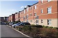
9
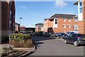
New housing estate - Banbury
A collection of new builds just to the east of Banbury railway station.
Image: © Fernweh
Taken: 30 Mar 2015
0.14 miles
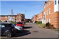
10
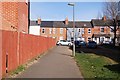
Path to Merton Street
Access from the new houses on Alma Road.
Image: © Fernweh
Taken: 30 Mar 2015
0.15 miles