IMAGES TAKEN NEAR TO
Middleton Close, BANBURY, OX16 4RS
Introduction
This page details the photographs taken nearby to Middleton Close, OX16 4RS by members of the Geograph project.
The Geograph project started in 2005 with the aim of publishing, organising and preserving representative images for every square kilometre of Great Britain, Ireland and the Isle of Man.

There are currently over 7.5m images from over14,400 individuals and you can help contribute to the project by visiting https://www.geograph.org.uk
Image Map
Images are licensed for reuse under creativecommons.org/licenses/by-sa/2.0
Notes
- Clicking on the map will re-center to the selected point.
- The higher the marker number, the further away the image location is from the centre of the postcode.
Image Listing (28 Images Found)
Images are licensed for reuse under creativecommons.org/licenses/by-sa/2.0
Image
Details
Distance

2
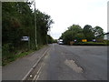
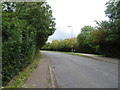
Middleton Road, Banbury
An industrial estate road.
Image: © JThomas
Taken: 28 Sep 2019
0.08 miles
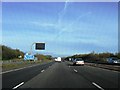
6
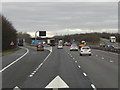
Northbound M40, Exit at Junction 11 (Banbury)
The exit sliproad from the northbound M40 towards the A422 (for Banbury) at Junction 11.
Image: © David Dixon
Taken: 21 Dec 2012
0.12 miles
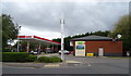
8

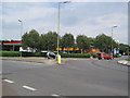
Houses in Princethorpe Drive, Grimsbury
Alongside the busy Ermont Way, but not accessed from it.
Image: © Christine Johnstone
Taken: 30 Mar 2015
0.13 miles
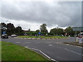
10
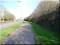
Cycleway and footpath, Ermont Way, Grimsbury
On the east side of the road.
Image: © Christine Johnstone
Taken: 30 Mar 2015
0.14 miles