IMAGES TAKEN NEAR TO
Broome Way, BANBURY, OX16 3WJ
Introduction
This page details the photographs taken nearby to Broome Way, OX16 3WJ by members of the Geograph project.
The Geograph project started in 2005 with the aim of publishing, organising and preserving representative images for every square kilometre of Great Britain, Ireland and the Isle of Man.

There are currently over 7.5m images from over14,400 individuals and you can help contribute to the project by visiting https://www.geograph.org.uk
Image Map
Images are licensed for reuse under creativecommons.org/licenses/by-sa/2.0
Notes
- Clicking on the map will re-center to the selected point.
- The higher the marker number, the further away the image location is from the centre of the postcode.
Image Listing (33 Images Found)
Images are licensed for reuse under creativecommons.org/licenses/by-sa/2.0
Image
Details
Distance
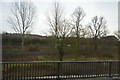
3

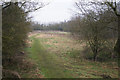
River Cherwell in Spiceball Park
Former landfill land now part of a nature reserve.
Image: © Bill Boaden
Taken: 24 Jan 2022
0.16 miles
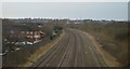
4
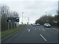
A4260 approaches junction with Hennef Way
Image: © Stuart Logan
Taken: 31 Mar 2013
0.16 miles
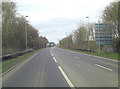
5
A4260 Concorde Avenue, Banbury
Nearing the roundabout on the A422.
Image: © Robin Webster
Taken: 18 Jul 2021
0.17 miles
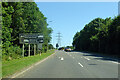
6
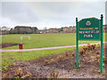
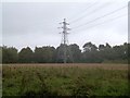
Moorfield Park
A recreation area to the north east of the town centre.
Image: © David P Howard
Taken: 9 Mar 2013
0.17 miles