IMAGES TAKEN NEAR TO
Manor Road, BANBURY, OX16 3JB
Introduction
This page details the photographs taken nearby to Manor Road, OX16 3JB by members of the Geograph project.
The Geograph project started in 2005 with the aim of publishing, organising and preserving representative images for every square kilometre of Great Britain, Ireland and the Isle of Man.

There are currently over 7.5m images from over14,400 individuals and you can help contribute to the project by visiting https://www.geograph.org.uk
Image Map
Images are licensed for reuse under creativecommons.org/licenses/by-sa/2.0
Notes
- Clicking on the map will re-center to the selected point.
- The higher the marker number, the further away the image location is from the centre of the postcode.
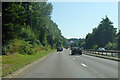
Image Listing (19 Images Found)
Images are licensed for reuse under creativecommons.org/licenses/by-sa/2.0
Image
Details
Distance
2
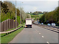
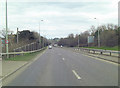
A422 Hennef Way, Banbury
Towards junction 11 of the M40. Hennef is Banbury's German twinning town.
Image: © Robin Webster
Taken: 18 Jul 2021
0.20 miles
5
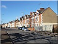
Three-storey terraced houses, Middleton Road
On the north side, just east of East Street, in Grimsbury.
Image: © Christine Johnstone
Taken: 30 Mar 2015
0.22 miles
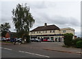
9
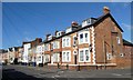
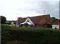
Three- and two-storey houses, Middleton Road
On the north side, just west of the junction with East Street, Grimsbury
Image: © Christine Johnstone
Taken: 30 Mar 2015
0.23 miles
10
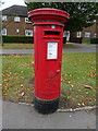
George VI postbox on Middleton Road, Banbury
Postbox No. OX16 1128.
See Image] for context.
Image: © JThomas
Taken: 28 Sep 2019
0.23 miles