IMAGES TAKEN NEAR TO
Ruscote Avenue, BANBURY, OX16 2NL
Introduction
This page details the photographs taken nearby to Ruscote Avenue, OX16 2NL by members of the Geograph project.
The Geograph project started in 2005 with the aim of publishing, organising and preserving representative images for every square kilometre of Great Britain, Ireland and the Isle of Man.

There are currently over 7.5m images from over14,400 individuals and you can help contribute to the project by visiting https://www.geograph.org.uk
Image Map
Images are licensed for reuse under creativecommons.org/licenses/by-sa/2.0
Notes
- Clicking on the map will re-center to the selected point.
- The higher the marker number, the further away the image location is from the centre of the postcode.
Image Listing (33 Images Found)
Images are licensed for reuse under creativecommons.org/licenses/by-sa/2.0
Image
Details
Distance
1
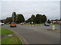
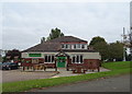
Roundabout on Ruscote Avenue (A422), Banbury
Image: © JThomas
Taken: 5 Oct 2019
0.03 miles
2
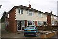
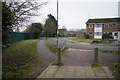
Nos. 119 & 117 Ruscote Avenue
There is an OS benchmark Image on the side of the left hand house near its front corner
Image: © Roger Templeman
Taken: 18 Apr 2016
0.03 miles
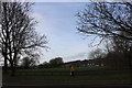
4
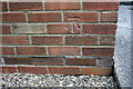
Benchmark on #119 Ruscote Avenue
Ordnance Survey cut mark benchmark described on the Bench Mark Database at http://www.bench-marks.org.uk/bm75405
Image: © Roger Templeman
Taken: 18 Apr 2016
0.04 miles
5
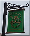
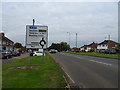
Sign for the Musketeer, Banbury
See Image] for context.
Image: © JThomas
Taken: 5 Oct 2019
0.05 miles