IMAGES TAKEN NEAR TO
Marston Close, BANBURY, OX16 2DQ
Introduction
This page details the photographs taken nearby to Marston Close, OX16 2DQ by members of the Geograph project.
The Geograph project started in 2005 with the aim of publishing, organising and preserving representative images for every square kilometre of Great Britain, Ireland and the Isle of Man.

There are currently over 7.5m images from over14,400 individuals and you can help contribute to the project by visiting https://www.geograph.org.uk
Image Map
Images are licensed for reuse under creativecommons.org/licenses/by-sa/2.0
Notes
- Clicking on the map will re-center to the selected point.
- The higher the marker number, the further away the image location is from the centre of the postcode.
Image Listing (12 Images Found)
Images are licensed for reuse under creativecommons.org/licenses/by-sa/2.0
Image
Details
Distance
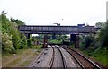
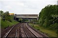
1

M40 motorway crosses the railway
In this instance, the Banbury-Leamington main line.
Image: © Peter Whatley
Taken: 19 Jun 2012
0.03 miles
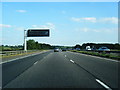
5
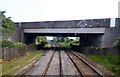
The M40 over the railway north of Banbury
Image: © Steve Daniels
Taken: 21 May 2009
0.14 miles
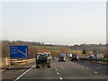
6

M40 motorway viewed from the A423 Southam Road
Image: © Mat Fascione
Taken: 23 May 2015
0.16 miles