IMAGES TAKEN NEAR TO
Claydon Close, BANBURY, OX16 2DB
Introduction
This page details the photographs taken nearby to Claydon Close, OX16 2DB by members of the Geograph project.
The Geograph project started in 2005 with the aim of publishing, organising and preserving representative images for every square kilometre of Great Britain, Ireland and the Isle of Man.

There are currently over 7.5m images from over14,400 individuals and you can help contribute to the project by visiting https://www.geograph.org.uk
Image Map
Images are licensed for reuse under creativecommons.org/licenses/by-sa/2.0
Notes
- Clicking on the map will re-center to the selected point.
- The higher the marker number, the further away the image location is from the centre of the postcode.
Image Listing (14 Images Found)
Images are licensed for reuse under creativecommons.org/licenses/by-sa/2.0
Image
Details
Distance
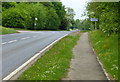
1
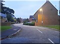
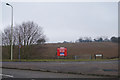
Hanwell View estate by Southam Road, Banbury
Image: © David Howard
Taken: 17 Oct 2021
0.08 miles
2
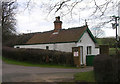
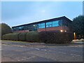
Old Toll House, Hardwick
Toll House in the parish of Hardwick with Tusmore, Hardwick Farm Lodge, Southam Road (A423), OX16.
Surveyed
Milestone Society National ID: OX.HAR
Image: © Alan Rosevear
Taken: Unknown
0.08 miles
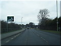
5
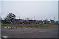
Roundabout - A423
Last one on the northern margins of Banbury.
Image: © Fernweh
Taken: 9 Mar 2013
0.13 miles
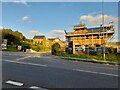
6
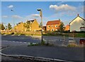
Cherry Fields estate by Southam Road, Banbury
Image: © David Howard
Taken: 17 Oct 2021
0.15 miles
8
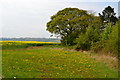
Dandelions and oilseed rape on Hardwick Hill
Image: © David Martin
Taken: 21 Apr 2014
0.16 miles