IMAGES TAKEN NEAR TO
Danesmoor, BANBURY, OX16 1QE
Introduction
This page details the photographs taken nearby to Danesmoor, OX16 1QE by members of the Geograph project.
The Geograph project started in 2005 with the aim of publishing, organising and preserving representative images for every square kilometre of Great Britain, Ireland and the Isle of Man.

There are currently over 7.5m images from over14,400 individuals and you can help contribute to the project by visiting https://www.geograph.org.uk
Image Map (Loading...)


Getting Data...Please wait
Leaflet Map data © OpenStreetMap
Images are licensed for reuse under creativecommons.org/licenses/by-sa/2.0
Notes
- Clicking on the map will re-center to the selected point.
- The higher the marker number, the further away the image location is from the centre of the postcode.
Image Listing (13 Images Found)
Images are licensed for reuse under creativecommons.org/licenses/by-sa/2.0
Image
Details
Distance
1
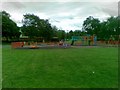
Play area off Longelandes Way, Ruscote
Image: © Alex McGregor
Taken: 17 Jun 2011
0.17 miles
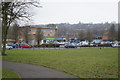
4
Longelandes Way, Ruscote
Ruscote is an extensive housing estate in north Banbury. This picture shows Longelandes Way near its junction with Highlands.
Image: © Stephen McKay
Taken: 29 Apr 2006
0.18 miles
6
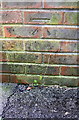
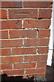
Benchmark on #92 Hearthway
Ordnance Survey cut mark benchmark described on the Bench Mark Database at http://www.bench-marks.org.uk/bm75520
Image: © Roger Templeman
Taken: 20 Apr 2016
0.21 miles
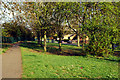
7
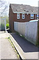
Footpath approaching #92 Hearthway
There is an OS benchmark Image on the side of the house at its far corner
Image: © Roger Templeman
Taken: 20 Apr 2016
0.21 miles
8
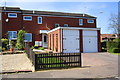
Houses on Forgeway with detached garages
There is an OS benchmark Image on the side of the left hand garage near its front corner
Image: © Roger Templeman
Taken: 20 Apr 2016
0.21 miles
9
Benchmark on garage of #4 Forgeway
Ordnance Survey cut mark benchmark described on the Bench Mark Database at http://www.bench-marks.org.uk/bm75069
Image: © Roger Templeman
Taken: 20 Apr 2016
0.22 miles
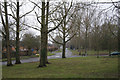
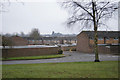
10
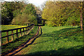
Path in Ruscote
This path follows the route of an old mineral railway and divides the Ruscote and Hardwick estates in the northern suburbs of Banbury. Although the scene looks rural, in reality the path lies adjacent to housing and an industrial estate.
Image: © Stephen McKay
Taken: 29 Apr 2006
0.22 miles