IMAGES TAKEN NEAR TO
High Furlong, BANBURY, OX16 1PR
Introduction
This page details the photographs taken nearby to High Furlong, OX16 1PR by members of the Geograph project.
The Geograph project started in 2005 with the aim of publishing, organising and preserving representative images for every square kilometre of Great Britain, Ireland and the Isle of Man.

There are currently over 7.5m images from over14,400 individuals and you can help contribute to the project by visiting https://www.geograph.org.uk
Image Map (Loading...)


Getting Data...Please wait
Leaflet Map data © OpenStreetMap
Images are licensed for reuse under creativecommons.org/licenses/by-sa/2.0
Notes
- Clicking on the map will re-center to the selected point.
- The higher the marker number, the further away the image location is from the centre of the postcode.
Image Listing (34 Images Found)
Images are licensed for reuse under creativecommons.org/licenses/by-sa/2.0
Image
Details
Distance
2
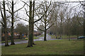
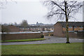
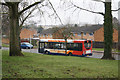
Longelandes Way, Ruscote
Ruscote is an extensive housing estate in north Banbury. This picture shows Longelandes Way near its junction with Highlands.
Image: © Stephen McKay
Taken: 29 Apr 2006
0.08 miles
4
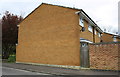
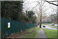
#99 Windrush
There is an OS benchmark Image in the bricks left of the wooden gate
Image: © Roger Templeman
Taken: 18 Apr 2016
0.10 miles
5
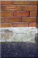
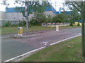
Benchmark on #99 Windrush
Ordnance Survey cut mark benchmark described on the Bench Mark Database at http://www.bench-marks.org.uk/bm74994
Image: © Roger Templeman
Taken: 18 Apr 2016
0.10 miles
8
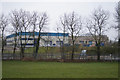
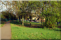
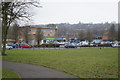
Large industrial premises
As seen from Longelandes Way.
Image: © Fernweh
Taken: 9 Mar 2013
0.11 miles