IMAGES TAKEN NEAR TO
Upton Close, BANBURY, OX16 1JD
Introduction
This page details the photographs taken nearby to Upton Close, OX16 1JD by members of the Geograph project.
The Geograph project started in 2005 with the aim of publishing, organising and preserving representative images for every square kilometre of Great Britain, Ireland and the Isle of Man.

There are currently over 7.5m images from over14,400 individuals and you can help contribute to the project by visiting https://www.geograph.org.uk
Image Map
Images are licensed for reuse under creativecommons.org/licenses/by-sa/2.0
Notes
- Clicking on the map will re-center to the selected point.
- The higher the marker number, the further away the image location is from the centre of the postcode.
Image Listing (4 Images Found)
Images are licensed for reuse under creativecommons.org/licenses/by-sa/2.0
Image
Details
Distance
1
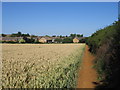
The edge of Banbury
The footpath from Wroxton runs along the edge of the field as it approaches the Neithrop area of Banbury.
Image: © David Stowell
Taken: 15 Jul 2006
0.10 miles
2
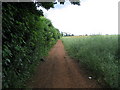
Field track
This track follows the field boundary from the folly ( Image ) to join the bridleway ( Image ) at the trees on the horizon. The crop is oilseed rape with occasional poppies.
Image: © E Gammie
Taken: 17 Jun 2007
0.18 miles

4
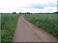
Bridleway
This bridleway runs across arable farmland at the western edge of Banbury. The crop here is oilseed rape.
Image: © E Gammie
Taken: 17 Jun 2007
0.24 miles