IMAGES TAKEN NEAR TO
Marjoram Walk, BANBURY, OX16 1ED
Introduction
This page details the photographs taken nearby to Marjoram Walk, OX16 1ED by members of the Geograph project.
The Geograph project started in 2005 with the aim of publishing, organising and preserving representative images for every square kilometre of Great Britain, Ireland and the Isle of Man.

There are currently over 7.5m images from over14,400 individuals and you can help contribute to the project by visiting https://www.geograph.org.uk
Image Map (Loading...)


Getting Data...Please wait
Leaflet Map data © OpenStreetMap
Images are licensed for reuse under creativecommons.org/licenses/by-sa/2.0
Notes
- Clicking on the map will re-center to the selected point.
- The higher the marker number, the further away the image location is from the centre of the postcode.
Image Listing (8 Images Found)
Images are licensed for reuse under creativecommons.org/licenses/by-sa/2.0
Image
Details
Distance
1
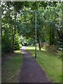
Footpath to Highlands
View SSW up a short footpath joining Salvia Close to Highlands.
Image: © David P Howard
Taken: 3 Aug 2013
0.18 miles
2
Erica Close, Banbury
Looking ESE along Erica Close, from a footpath leading to Highlands.
Image: © David P Howard
Taken: 3 Aug 2013
0.20 miles
3
Highlands, Banbury
View WNW along Highlands near the junction with Ferriston.
Image: © David P Howard
Taken: 3 Aug 2013
0.21 miles
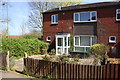
4
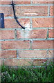
Benchmark on #14 Ferriston
Ordnance Survey cut mark benchmark described on the Bench Mark Database at http://www.bench-marks.org.uk/bm75696
Image: © Roger Templeman
Taken: 20 Apr 2016
0.21 miles
5
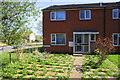
#14 Ferriston
There is an OS benchmark Image on the left hand side of the house near its front corner
Image: © Roger Templeman
Taken: 20 Apr 2016
0.22 miles
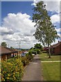
6
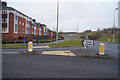
'Local Centre'
It says it all. Turning off Dukes Meadow Drive into the new suburban development.
Image: © Fernweh
Taken: 9 Mar 2013
0.23 miles
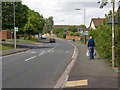
8
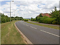
Dukes Meadow Drive
View ESE down Dukes Meadow Drive which is now the northern edge of the Banbury conurbation.
Image: © David P Howard
Taken: 3 Aug 2013
0.25 miles