IMAGES TAKEN NEAR TO
Warwick Road, BANBURY, OX16 1AT
Introduction
This page details the photographs taken nearby to Warwick Road, OX16 1AT by members of the Geograph project.
The Geograph project started in 2005 with the aim of publishing, organising and preserving representative images for every square kilometre of Great Britain, Ireland and the Isle of Man.

There are currently over 7.5m images from over14,400 individuals and you can help contribute to the project by visiting https://www.geograph.org.uk
Image Map
Images are licensed for reuse under creativecommons.org/licenses/by-sa/2.0
Notes
- Clicking on the map will re-center to the selected point.
- The higher the marker number, the further away the image location is from the centre of the postcode.
Image Listing (35 Images Found)
Images are licensed for reuse under creativecommons.org/licenses/by-sa/2.0
Image
Details
Distance
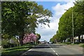
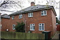
1
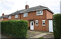
Nos. 237 & 239 Warwick Road
There is an OS benchmark Image on the front of the right hand house at the junction with its garage
Image: © Roger Templeman
Taken: 18 Apr 2016
0.01 miles
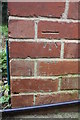
2
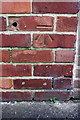
Benchmark on #239 Warwick Road
Ordnance Survey cut mark benchmark described on the Bench Mark Database at http://www.bench-marks.org.uk/bm75408
Image: © Roger Templeman
Taken: 18 Apr 2016
0.01 miles
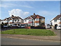
6
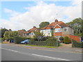
Houses on the Warwick Rd Banbury
These 1930's semi detached houses are on the north side of the A422 close to its junction with Cromwell Rd and Ruscote Avenue.
Image: © Nigel Mykura
Taken: 14 Sep 2012
0.06 miles
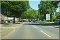
8
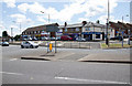
Shops by the roundabout
A row of shops including A & C Fish Bar, on the B4100 Warwick Road opposite the end of Ruscote Avenue.
Image: © David P Howard
Taken: 3 Aug 2013
0.10 miles
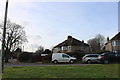
9
Nos. 111 & 113 Cromwell Road
There is an OS benchmark Image on the side of the right hand house near its front corner
Image: © Roger Templeman
Taken: 18 Apr 2016
0.11 miles
10
Benchmark on #113 Cromwell Road
Ordnance Survey cut mark benchmark described on the Bench Mark Database at http://www.bench-marks.org.uk/bm75409
Image: © Roger Templeman
Taken: 18 Apr 2016
0.11 miles