IMAGES TAKEN NEAR TO
Penrose Drive, BANBURY, OX16 0PX
Introduction
This page details the photographs taken nearby to Penrose Drive, OX16 0PX by members of the Geograph project.
The Geograph project started in 2005 with the aim of publishing, organising and preserving representative images for every square kilometre of Great Britain, Ireland and the Isle of Man.

There are currently over 7.5m images from over14,400 individuals and you can help contribute to the project by visiting https://www.geograph.org.uk
Image Map
Images are licensed for reuse under creativecommons.org/licenses/by-sa/2.0
Notes
- Clicking on the map will re-center to the selected point.
- The higher the marker number, the further away the image location is from the centre of the postcode.
Image Listing (35 Images Found)
Images are licensed for reuse under creativecommons.org/licenses/by-sa/2.0
Image
Details
Distance
1
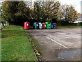
Recycling area outside the Admiral Holland, Banbury
Viewed from Woodgreen Avenue. The recycling bins are in a corner of this http://www.geograph.org.uk/photo/4211652 pub's car park.
Image: © Jaggery
Taken: 18 Oct 2014
0.06 miles
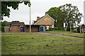
3
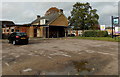
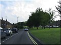
Admiral Holland, Banbury
Suburban pub in Woodgreen Avenue, on the corner of The Fairway.
Born in Middleton Cheney, Banbury in 1887, Vice Admiral Lancelot Holland commanded the British force in the Battle of the Denmark Strait in May 1941 against the German battleship Bismarck.
Holland was killed on board HMS Hood during the battle.
Image: © Jaggery
Taken: 18 Oct 2014
0.07 miles
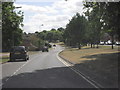
4
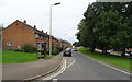
Woodgreen Avenue, Banbury
A dual carriageway at this point.
Image: © JThomas
Taken: 5 Oct 2019
0.08 miles
6
On Ho, Banbury
Chinese takeaway at 74 Orchard Way, at the edge of a small group of shops.
A Nisa Local store is on the right.
Image: © Jaggery
Taken: 18 Oct 2014
0.10 miles
7
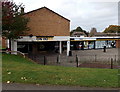
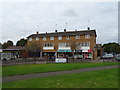
Orchard Way shops, Banbury
From left to right are a Nisa Local convenience store, Coral betting shop,
Rowlands Pharmacy and McColl's newsagents & convenience store.
Image: © Jaggery
Taken: 18 Oct 2014
0.11 miles
8
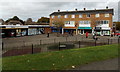
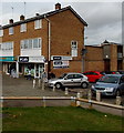
Post Office and shops off Orchard Way, Banbury
Image: © JThomas
Taken: 5 Oct 2019
0.12 miles
9
McColl's, Orchard Way, Banbury
Newsagents and convenience store at 56 Orchard Way. Rowlands Pharmacy is on the left.
Image: © Jaggery
Taken: 18 Oct 2014
0.12 miles