IMAGES TAKEN NEAR TO
Fairfax Close, BANBURY, OX16 0NN
Introduction
This page details the photographs taken nearby to Fairfax Close, OX16 0NN by members of the Geograph project.
The Geograph project started in 2005 with the aim of publishing, organising and preserving representative images for every square kilometre of Great Britain, Ireland and the Isle of Man.

There are currently over 7.5m images from over14,400 individuals and you can help contribute to the project by visiting https://www.geograph.org.uk
Image Map
Images are licensed for reuse under creativecommons.org/licenses/by-sa/2.0
Notes
- Clicking on the map will re-center to the selected point.
- The higher the marker number, the further away the image location is from the centre of the postcode.
Image Listing (30 Images Found)
Images are licensed for reuse under creativecommons.org/licenses/by-sa/2.0
Image
Details
Distance
1
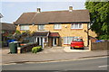
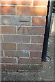
Nos. 54 and 52 Bretch Hill
There is an OS benchmark Image on the side of the right hand house near its front angle
Image: © Roger Templeman
Taken: 16 May 2014
0.05 miles
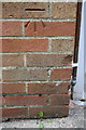
2
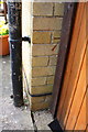
Part of benchmark on #52 Bretch Hill
Ordnance Survey cut mark benchmark described on the Bench Mark Database at http://www.bench-marks.org.uk/bm57587
Image: © Roger Templeman
Taken: 16 May 2014
0.05 miles
3
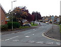
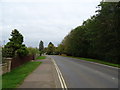
Bretch Hill, Banbury
Bretch Hill climbs away from Woodgreen Avenue.
Image: © Jaggery
Taken: 18 Oct 2014
0.11 miles
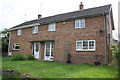
4
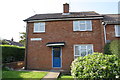
#68 Mascord Road
There is an OS benchmark Image on the left hand side of the house near its front corner
Image: © Roger Templeman
Taken: 16 May 2014
0.13 miles
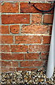
5
Benchmark on #68 Mascord Road
Ordnance Survey cut mark benchmark described on the Bench Mark Database at http://www.bench-marks.org.uk/bm57588
Image: © Roger Templeman
Taken: 16 May 2014
0.14 miles
6
Benchmark on #108 Woodgreen Avenue
Ordnance Survey cut mark benchmark described on the Bench Mark Database at http://www.bench-marks.org.uk/bm57586
Image: © Roger Templeman
Taken: 16 May 2014
0.14 miles
7
Nos. 108 and 106 Woodgreen Avenue
There is an OS benchmark Image of the side of the left hand house near it front corner
Image: © Roger Templeman
Taken: 16 May 2014
0.15 miles
8
Benchmark on #292 Broughton Road
Ordnance Survey cut mark benchmark described on the Bench Mark Database at http://www.bench-marks.org.uk/bm57585
Image: © Roger Templeman
Taken: 16 May 2014
0.15 miles
10
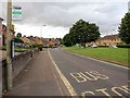
Bus Stop on Woodgreen Avenue
Looking NW down Woodgreen Avenue towards the junction with Bretch Hill.
Image: © David P Howard
Taken: 2 Aug 2012
0.15 miles