IMAGES TAKEN NEAR TO
George Parish Road, BANBURY, OX16 0FN
Introduction
This page details the photographs taken nearby to George Parish Road, OX16 0FN by members of the Geograph project.
The Geograph project started in 2005 with the aim of publishing, organising and preserving representative images for every square kilometre of Great Britain, Ireland and the Isle of Man.

There are currently over 7.5m images from over14,400 individuals and you can help contribute to the project by visiting https://www.geograph.org.uk
Image Map
Images are licensed for reuse under creativecommons.org/licenses/by-sa/2.0
Notes
- Clicking on the map will re-center to the selected point.
- The higher the marker number, the further away the image location is from the centre of the postcode.
Image Listing (9 Images Found)
Images are licensed for reuse under creativecommons.org/licenses/by-sa/2.0
Image
Details
Distance
1
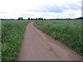
Bridleway
This bridleway runs across arable farmland at the western edge of Banbury. The crop here is oilseed rape.
Image: © E Gammie
Taken: 17 Jun 2007
0.14 miles
2
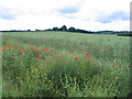
Poppies and oilseed rape
Poppies and other wild flowers mix in with the crop at the edge of the bridleway ( Image ).
Image: © E Gammie
Taken: 17 Jun 2007
0.14 miles

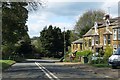
4
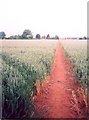
Footpath, Drayton
A footpath to Drayton village cutting diagonally through a field of wheat. Looking towards Drayton, from near the gate into the field by Drayton School on the A422.
Image: © E Gammie
Taken: 18 Jun 2006
0.21 miles
5
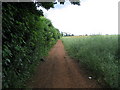
Field track
This track follows the field boundary from the folly ( Image ) to join the bridleway ( Image ) at the trees on the horizon. The crop is oilseed rape with occasional poppies.
Image: © E Gammie
Taken: 17 Jun 2007
0.22 miles
6
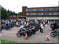
Drayton School
Participants in the 2006 Banbury Run, gathered before the start, in the car park of Drayton School.
From September 2007 Drayton School became North Oxfordshire Academy.
Image: © E Gammie
Taken: 18 Jun 2006
0.23 miles
8
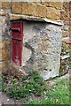
Old milestone and post box in front of Crickle Cottage, Stratford Road
The milestone indicates Birmingham 38, London 70, Warwick 18 miles. The stone has been moved from its original location beside Warwick Road, Banbury at SP 44098 41227.
The stone has Milestone Society National ID: OX_BAWA02
Image: © Roger Templeman
Taken: 18 Apr 2016
0.25 miles
9
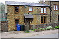
Crickle Cottage, Stratford Road
There is an old milestone Image cemented to an EIIR post box to the right of the house's front door
Image: © Roger Templeman
Taken: 18 Apr 2016
0.25 miles