IMAGES TAKEN NEAR TO
Fiennes Road, BANBURY, OX16 0ET
Introduction
This page details the photographs taken nearby to Fiennes Road, OX16 0ET by members of the Geograph project.
The Geograph project started in 2005 with the aim of publishing, organising and preserving representative images for every square kilometre of Great Britain, Ireland and the Isle of Man.

There are currently over 7.5m images from over14,400 individuals and you can help contribute to the project by visiting https://www.geograph.org.uk
Image Map
Images are licensed for reuse under creativecommons.org/licenses/by-sa/2.0
Notes
- Clicking on the map will re-center to the selected point.
- The higher the marker number, the further away the image location is from the centre of the postcode.
Image Listing (15 Images Found)
Images are licensed for reuse under creativecommons.org/licenses/by-sa/2.0
Image
Details
Distance
1
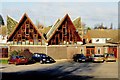
St. Joseph the Worker RC church, Banbury
Set in a residential area. Not easy to find.
Image: © Julian Dowse
Taken: 26 Dec 2008
0.06 miles
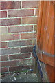
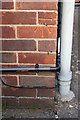
2
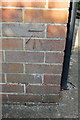
Benchmark on #68 Mascord Road
Ordnance Survey cut mark benchmark described on the Bench Mark Database at http://www.bench-marks.org.uk/bm57588
Image: © Roger Templeman
Taken: 16 May 2014
0.14 miles
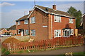
3
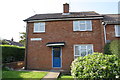
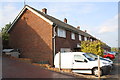
#68 Mascord Road
There is an OS benchmark Image on the left hand side of the house near its front corner
Image: © Roger Templeman
Taken: 16 May 2014
0.14 miles
4
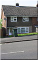
#158 Bretch Hill
There is an OS benchmark Image on the side of the house where the wooden gate is fixed
Image: © Roger Templeman
Taken: 16 May 2014
0.14 miles
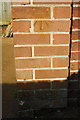
5
Part of benchmark on #158 Bretch Hill
Ordnance Survey cut mark benchmark described on the Bench Mark Database at http://www.bench-marks.org.uk/bm57589
Image: © Roger Templeman
Taken: 16 May 2014
0.15 miles
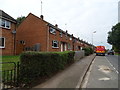
6
Semis at junction of Bretch Hill (#208) and Conway Drive (#19)
There is an OS benchmark Image on the front of the right hand house near the facing corner, left of the white downpipe
Image: © Roger Templeman
Taken: 16 May 2014
0.20 miles
7
Benchmark on #208 Bretch Hill
Ordnance Survey cut mark benchmark described on the Bench Mark Database at http://www.bench-marks.org.uk/bm57590
Image: © Roger Templeman
Taken: 16 May 2014
0.21 miles
9
Nos. 64 to 58 (evens) Prescott Avenue
There is an OS benchmark Image on the front corner on the side of the nearest house
Image: © Roger Templeman
Taken: 16 May 2014
0.22 miles
10
Benchmark on #64 Prescott Avenue
Ordnance Survey cut mark benchmark described on the Bench Mark Database at http://www.bench-marks.org.uk/bm57592
Image: © Roger Templeman
Taken: 16 May 2014
0.23 miles