IMAGES TAKEN NEAR TO
Sandy Lane, OXFORD, OX1 5HN
Introduction
This page details the photographs taken nearby to Sandy Lane, OX1 5HN by members of the Geograph project.
The Geograph project started in 2005 with the aim of publishing, organising and preserving representative images for every square kilometre of Great Britain, Ireland and the Isle of Man.

There are currently over 7.5m images from over14,400 individuals and you can help contribute to the project by visiting https://www.geograph.org.uk
Image Map (Loading...)


Getting Data...Please wait
Leaflet Map data © OpenStreetMap
Images are licensed for reuse under creativecommons.org/licenses/by-sa/2.0
Notes
- Clicking on the map will re-center to the selected point.
- The higher the marker number, the further away the image location is from the centre of the postcode.
Image Listing (7 Images Found)
Images are licensed for reuse under creativecommons.org/licenses/by-sa/2.0
Image
Details
Distance
1
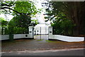
Entrance to 'Wootton Grange' with rendered gateposts
Image: © Roger Templeman
Taken: 23 Sep 2015
0.08 miles

3
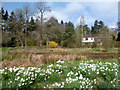
Elizabeth Daryush Memorial Garden
Elizabeth Daryush was the daughter of Poet Laureate Robert Bridges. She and her Iranian husband Ali Akbar Daryush created a garden here which they bequeathed to the Oxford Preservation Trust.
Image: © Des Blenkinsopp
Taken: 25 Apr 2013
0.18 miles