IMAGES TAKEN NEAR TO
Chilswell Lane, OXFORD, OX1 5BN
Introduction
This page details the photographs taken nearby to Chilswell Lane, OX1 5BN by members of the Geograph project.
The Geograph project started in 2005 with the aim of publishing, organising and preserving representative images for every square kilometre of Great Britain, Ireland and the Isle of Man.

There are currently over 7.5m images from over14,400 individuals and you can help contribute to the project by visiting https://www.geograph.org.uk
Image Map (Loading...)


Getting Data...Please wait
Leaflet Map data © OpenStreetMap
Images are licensed for reuse under creativecommons.org/licenses/by-sa/2.0
Notes
- Clicking on the map will re-center to the selected point.
- The higher the marker number, the further away the image location is from the centre of the postcode.
Image Listing (6 Images Found)
Images are licensed for reuse under creativecommons.org/licenses/by-sa/2.0
Image
Details
Distance
1
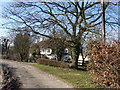
House on Hinksey Hill
The track is a bridleway.
Image: © David Hawgood
Taken: 7 Feb 2007
0.05 miles
2
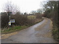
Chilswell Lane
Chilswell lane bridleway to Cumnor
Image: © Shaun Ferguson
Taken: 12 Mar 2010
0.08 miles
3
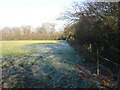
Frosted field on Hinksey Hill
A hard frost overnight followed by a sunny day, so most of the frost has gone by early afternoon.
Image: © David Hawgood
Taken: 7 Feb 2007
0.10 miles
5
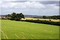
Looking across a field towards the bridleway and a tractor
Image: © Steve Daniels
Taken: 22 Jul 2009
0.22 miles
6
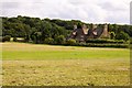
Looking across a field towards Chilswell Farm Cottages
Image: © Steve Daniels
Taken: 22 Jul 2009
0.25 miles